Fact Sheet 1: Overview
This factsheet is part of a series that describes the iRAP methodology. It provides an overview of the Star Rating and Safer Roads Investment Plan processes and a list of factsheets in the series.
Related documents
This factsheet should be read in conjunction with:
- Other factsheets in the iRAP Methodology Fact Sheet
- iRAP Road Attribute Risk Factor Fact Sheets.
- Road Safety Toolkit.
Introduction
iRAP was established to help tackle the devastating social and economic cost of road crashes. Without intervention, the annual number of road deaths worldwide is projected to increase to some 2.4 million by 2030. The majority of these will occur in low-income and middle-income countries, which already suffer nine out of ten of the world’s road deaths. Almost half of those killed will be vulnerable road users – motorcyclists, bicyclists and pedestrians.
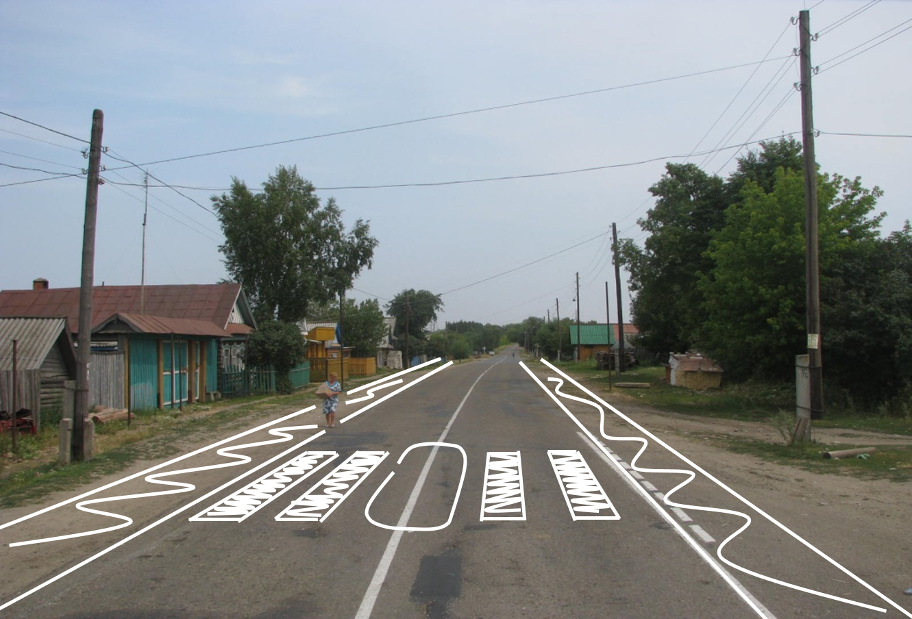
Large as the problem is, making roads safe is by no means an insurmountable challenge; the requisite research, technology and expertise to save lives already exists. Road safety engineering makes a direct contribution to the reduction of road death and injury. Well-designed intersections, safe roadsides and appropriate road cross-sections can significantly decrease the risk of a motorised vehicle crashes occurring and the severity of crashes that do occur. Footpaths, pedestrian crossings and bicycle paths can substantially cut the risk that pedestrians and bicyclists will be killed or injured by avoiding the need for them to mix with motorised vehicles. Motorcycle lanes can minimise the risk of death and injury for motorcyclists.
By building on the work of Road Assessment Programmes (RAP) in high-income countries (EuroRAP, AusRAP, usRAP and KiwiRAP) and with the expertise of leading road safety research organisations worldwide, including ARRB Group (Australia), TRL (United Kingdom), MRI Global (United States) and MIROS (Malaysia), iRAP has developed four globally-consistent protocols to assess and improve the safety of roads (see box below).
The iRAP Protocols
1. Risk Maps use detailed crash data to illustrate the actual number of deaths and injuries on a road network.
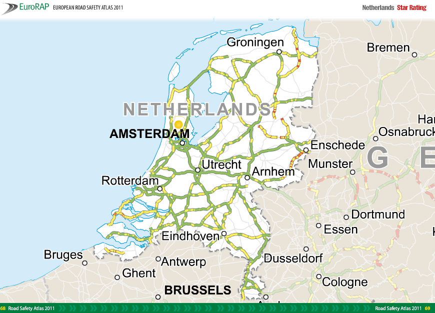
2. Star Ratings provide a simple and objective measure of the level of safety provided by a road’s design.
3. Safer Roads Investment Plans draw on approximately 90 proven road improvement options to generate affordable and economically sound infrastructure options for saving lives.
4. Performance Tracking enables the use of Star Ratings and Risk Maps to track road safety performance and establish policy positions.
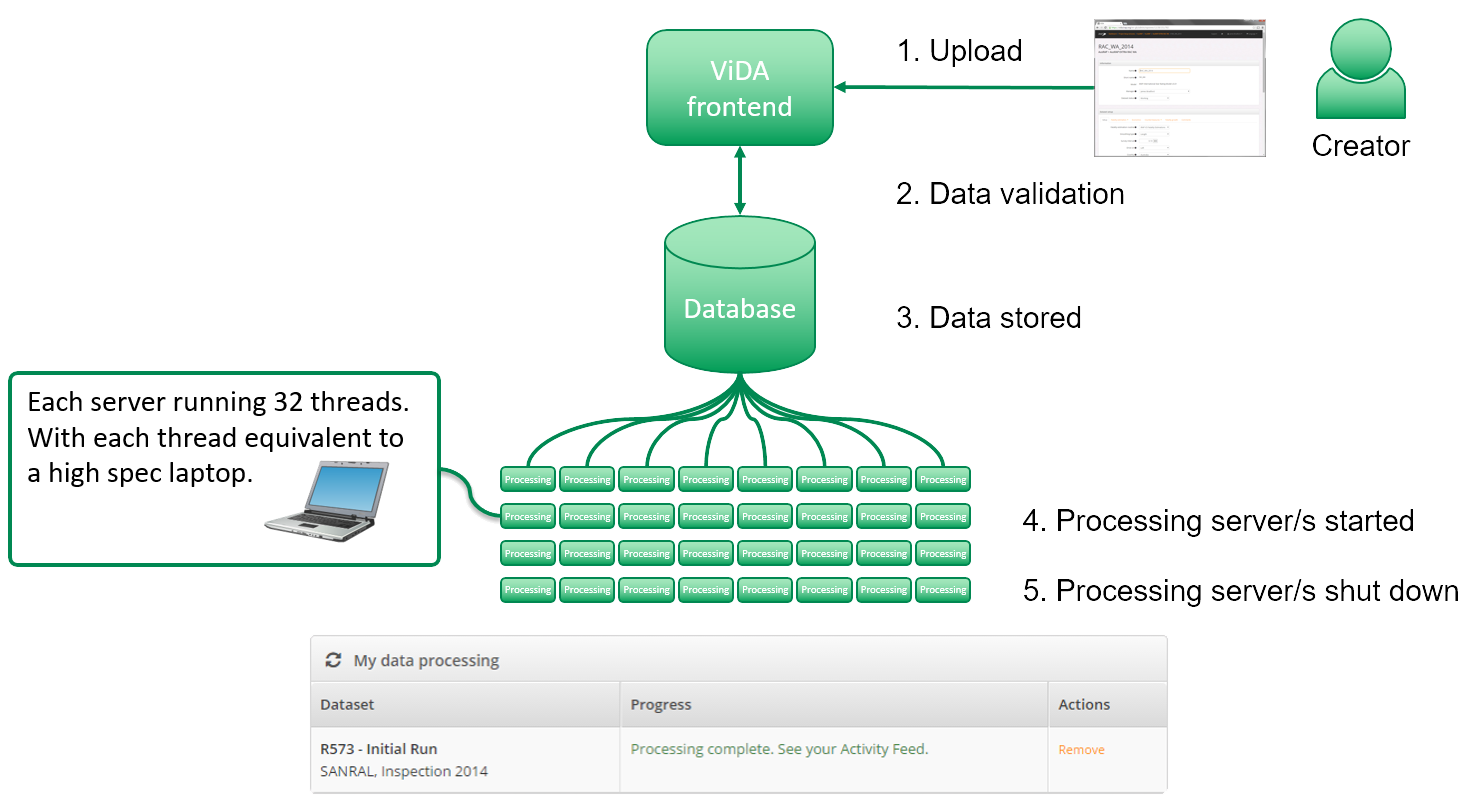
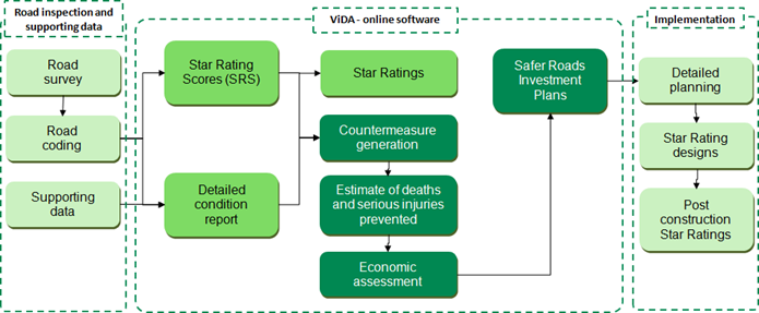
The focus of this fact sheet series is on the second and third protocols – Star Ratings and Safer Roads Investment Plans. The figure below illustrates the process used to undertake these protocols. Star Ratings and Safer Roads Investment Plans can be used as part of a systematic, proactive approach to road infrastructure risk assessment and renewal based on research about where severe crashes are likely to occur and how they can be prevented.
The iRAP Star Rating and Safer Roads Investment Plan process
What are Star Ratings?
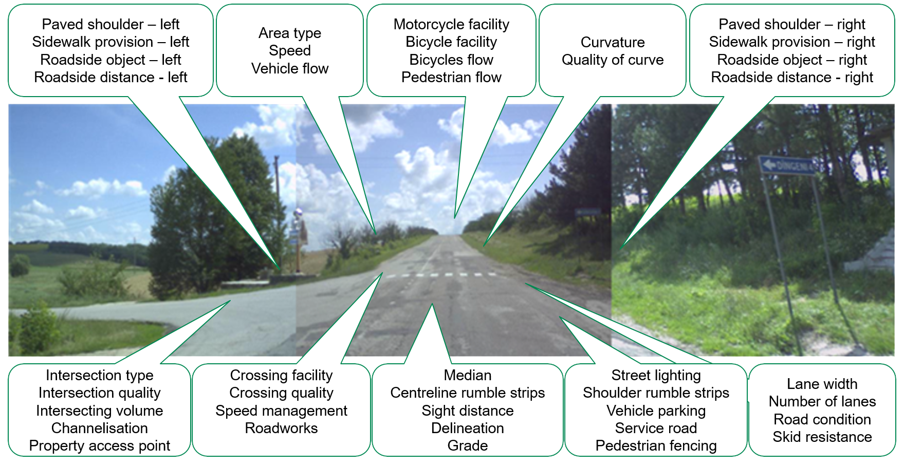
Star Ratings involve an inspection of road infrastructure attributes that are known to have an impact on the likelihood of a crash and its severity. Between 1 and 5-stars are awarded depending on the level of safety which is ‘built-in’ to the road. The safest roads (4- and 5-star) have road safety attributes that are appropriate for the prevailing traffic speeds. Road infrastructure attributes on a safe road might include separation of opposing traffic by a wide median or barrier, good line-marking and intersection design, wide lanes and sealed (paved) shoulders, roadsides free of unprotected hazards such as poles, and good provision for bicyclists and pedestrians such as footpaths, bicycle lanes and pedestrian crossings. The least safe roads (1- and 2-star) do not have road safety attributes that are appropriate for the prevailing traffic speeds. These are often single-carriageway roads with frequent curves and intersections, narrow lanes, unsealed shoulders, poor line markings, hidden intersections and unprotected roadside hazards such as trees, poles and steep embankments close to the side of the road. They also do not adequately accommodate for bicyclists and pedestrians with the use of footpaths, bicycle paths and crossings.
What are Safer Roads Investment Plans?
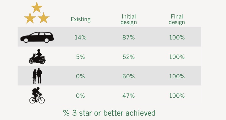
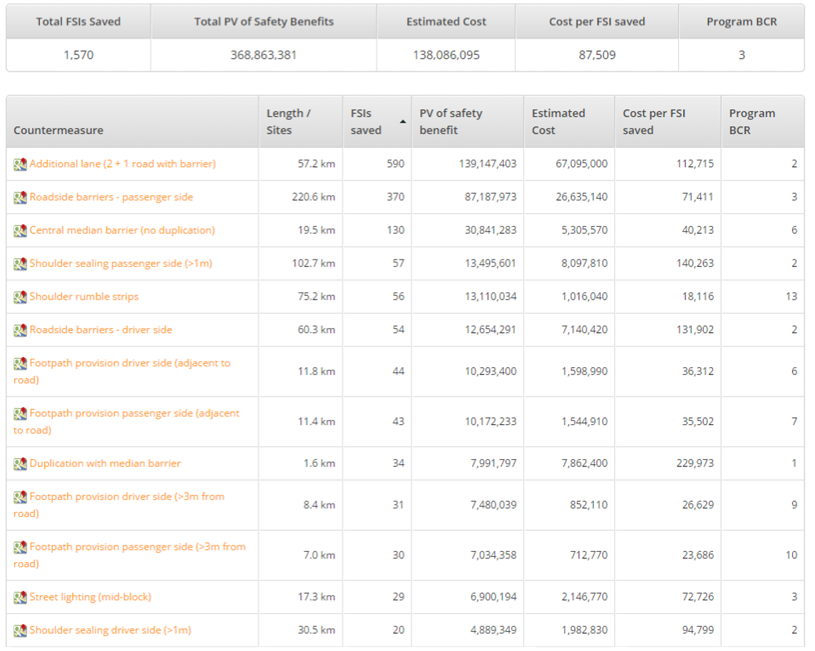
Safer Roads Investment Plans (SRIP) are a prioritised list of countermeasures that can cost-effectively improve Star Ratings and reduce infrastructure-related risk. The plans are based on an economic analysis of a range of countermeasures, which is undertaken by comparing the cost of implementing the countermeasure with the reduction in crash costs that would result from its implementation. The plans contain extensive planning and engineering information such as road attribute records, countermeasure proposals and economic assessments for 100 metre segments of a road network.
What is ViDA?
ViDA (meaning ‘life’ in Spanish) is iRAP’s online software, located at http://vida.irap.org. ViDA is used to perform all iRAP Star Rating and Safer Roads Investment Plan analyses.
Methodology fact sheet series
The fact sheets in this series describe the methodology used to calculate Star Ratings and produce Safer Roads Investment Plans.
The series includes the following factsheets:
* Fact Sheet 1: Overview
* Fact Sheet 2: Model development history
* Fact Sheet 2a: Model Versions
* Fact Sheet 3: Road attributes
* Fact Sheet 4: Crash types
* Fact Sheet 5: External flow and median traversability
* Fact Sheet 6: Star Rating Score Equations
* Fact Sheet 7: Star Rating bands
* Fact Sheet 8: Smoothed Star Ratings
* Fact Sheet 9: Star Rating worked example
* Fact Sheet 10: Casualty estimations and calibration
* Fact Sheet 11: Countermeasures
* Fact Sheet 12: Multiple countermeasures
* Fact Sheet 13: Economic analysis
* Fact Sheet 14: Star Rating for Schools
* Fact Sheet 15: Model localisation
References
World Health Organisation (2009) Global Status Report on Road Safety: Time for Action. http://www.who.int/violence_injury_prevention/publications/road_traffic/en/index.html.
16 April 2014, © International Road Assessment Programme (iRAP) 2014.
