Reproduced from TomTom blog. Story by Bart Volckaert.
Road crashes take a huge toll on individuals, their families, and nations, claiming the lives of more than 3,000 people each day and costing 3% of global GDP on average. By identifying and prioritizing infrastructure improvements, road authorities can make the network safer for all users. Here’s how TomTom’s mobile mapping (MoMa) data helps streamline that process.
As the world becomes more developed, more roads are built, and more people travel on them. While this is positive for mobility and economic growth, a bigger, busier road network brings serious safety concerns. Every year, some 1.3 million people lose their lives in road traffic crashes according to the World Health Organization. An even larger number – between 20 and 50 million people – suffer non-fatal injuries in accidents on our roads. (More detailed figures can be found on Vaccines for Roads.) To tackle this issue, the United Nations General Assembly has set an ambitious target of halving the global number of deaths and injuries from road traffic crashes by 2030.
Reaching for the stars
To meet this goal, UN Member States have agreed on 12 global targets for road safety, which include ensuring all new roads are built to a three-star or better standard (or achieve technical standards for all road users that take into account road safety). Another example, Target 4, says that by 2030 more than 75% of travel is on roads that meet technical standards for all road users that take into account road safety.
Established by the non-profit International Road Assessment Programme (iRAP), star ratings provide an objective measure of the level of safety which is “built-in” to the road for vehicle occupants, motorcyclists, cyclists and pedestrians. The higher the star rating – measured on a scale of one to five – the safer the road.
A road’s star rating depends on a variety of factors relating to the nature of the road. For example, a four-star road is likely to have safety barriers at the side of the road and in the central reservation, and to have junctions with motorway-style slip roads. In contrast, low scoring roads tend to have hazardous fixed objects close to the road, frequent junctions and no head-on protection from oncoming traffic, such as a central barrier.
According to iRAP, a person’s risk of death or serious injury is reduced by 50% with each improvement in a road’s star rating – making them a valuable tool for measuring and interpreting road safety.
Data on the move
By determining the star rating of roads in their network, road authorities know where to take tangible steps to improve both the quality and safety of roads.
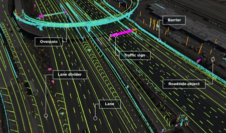
TomTom provides high-quality, globally consistent map data and services to support iRAP modeling – making it easier for road authorities to evaluate and improve the safety of their network. One of the cornerstones of TomTom’s approach is MoMa, a technique used to collect real-world geographical information.

TomTom MoMa cars recently had their 20th anniversary. They’ve been mapping the world’s roads longer than anyone else.
TomTom MoMa vehicles are equipped with the latest 360˚ “Ladybug” cameras and “Velodyne” LiDAR. These sensors, combined with DGPS (Differential GPS), collect more than 700,000 data points, to an accuracy of within two centimeters. For every kilometer driven, a MoMa vehicle captures approximately 3.8 billion pixels, resulting in high-quality images.
iRAP accreditation
The TomTom MoMa data has now been coupled with software tools that ensure high-quality coding of iRAP attributes. Fully accredited by iRAP, the approach ensures road attributes can be efficiently recorded by coding teams using TomTom’s MoMa. This opens the opportunity for the multi-million kilometers of existing TomTom data to be used for iRAP assessments.
Rich information reveals new insights
TomTom stores the data captured by its MoMa vehicles in a huge archive consisting of millions of kilometers of road data. This rich store of information is licensed to customers through TomTom’s MoMa as a Service.
The MoMa images and LiDAR (3D point cloud) data are designed for easy integration with asset management and analysis tools. Almost any feature captured within an image or point cloud can be extracted for analysis, from road signage and street furniture (lights, shelters and barriers) to road markings and bridge types.
By using mobile mapping images iRAP can build an understanding of road quality, highlighting to authorities where infrastructure can be improved.
The power of GPS Probe data to support UN Targets
TomTom continues to add to MoMa as a Service, to help customers get even more out of our location information. That includes a new data collection approach, where we aggregate and analyze GPS data from our network of 600+ million connected devices to identify the most-driven roads globally. With insights into traffic flow, customers can identify the most traffic-dense areas of their network, as well as potential accident crash hotspots, and take targeted action to reduce congestion and boost safety.
Making a real impact on road safety
Today, TomTom MoMa data can be used by organizations to extract different types of road features and performing quality measurements. It empowers road agencies to inspect, manage and improve the quality – and thus the safety – of their roads.
TomTom’s data offers a useful complement to traditional road network surveys, giving organizations a quick and cost-effective way to identify iRAP attributes and benefit from the integrated use of LiDAR and image data to accurately determine the Star Rating of roads. With TomTom’s wealth of mapping data and expertise available as a service, customers gain direct access to the information they need to assess and improve road safety without a hefty up-front investment.
TomTom is also an active partner of the AiRAP innovations, that are exploring ways to enable accelerated and intelligent RAP data for road agencies using artificial intelligence and machine learning.


