Select Page
ImageDetailsYear
5 Star cities V5_Page_1

5-Star Cities for all road users

LOCATION: GLOBAL


For cities embracing Vision Zero targets, a 5-Star target for bicycling and walking and other road users can help provide an objective target and measure of safe and sustainable transport options for all transport modes.
Read more2019-04-102021
CS-CBE_Sweden-Road-21

Road No. 21, Vanneberga

LOCATION: SWEDEN

The information detailed in this case study has been provided by iRAP and EuroRAP. It deals with how improvements to roads and roadsides can reduce serious injury and in particular the use of the 2+1 with wire rope median as used in Sweden and an example on Road No. 21 near Vanneberga in the south of that country. 
Read more2021-03-312021
CS-CE_Sweden-National-Programme

National programme efficacy

LOCATION: SWEDEN

The information detailed in this case study has been provided by iRAP and EuroRAP. It deals with how improvements to roads and roadsides can reduce serious injury and in particular the use of the 2+1 with wire rope median as used in Sweden.
Read more2021-03-312021
CS-CX_Netherlands-Generic

Generic case of selecting sites for 2+1 with median barrier N366, StadsKanaal – Veendam

LOCATION: NETHERLANDS

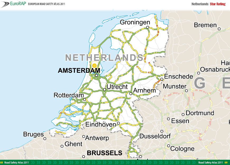
This case study shows how Star Rating maps, Safer Roads Investment Plans (SRIPS) and tools within the iRAP software platform ViDA maps may be used to guide site selection for 2+1 roads with a median barrier.
Read more2021-03-312021
CS-BX_Slovakia-R1

R1 Trnava - Nitra (CH.0+000 – 38+200)

LOCATION: SLOVAKIA

In 2015, 2741 people died on Slovakia’s roads as a result of road crashes and a further 10911 were seriously injured. The estimated Gross Domestic Product loss due to road traffic crashes was 1,4% in 20132. The number of road deaths and crashes in Slovakia and on motorways and expressways had fluctuated between
2012 and 2015 and were certainly not showing the hoped-for sustained decrease and contribution to European targets. This was a common problem in Europe at that time.
Read more2021-03-312021
CS-BD_Moldova-M3

National Road M3 - Congaz

LOCATION: MOLDOVA

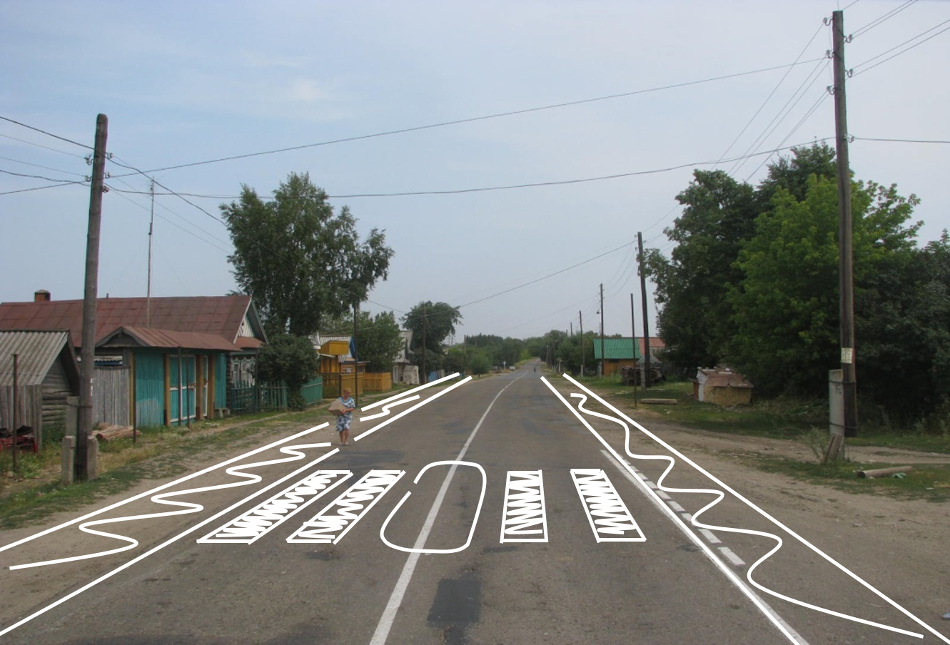
The information in this case study has been provided by the Automobile Club of Moldova (ACM). Scene photographs and other information come from the report for the RADAR project prepared for ACM. It is included here as part of the capitalisation of that project foreseen in the SLAIN proposal (section 2.2). The case study concerns assessment of a pedestrian crossing installation using the iRAP Star Rating for Schools (SR4S) methodology. From a network assessment perspective, surveys using the iRAP methodology have shown that in south-east Europe pedestrian crossings are often of a poor quality.
Read more2021-03-312021
CS-EB_Moldova

Cross-sections and mid-block National Road M2-R7 Saratenii-Soroca-Drochia Junction

LOCATION: MOLDOVA

This case study focuses on the influence that elements of design may have on the Star Rating Score (SRS), the values in the scale that determine which of the Star Rating bands (1-5, with 5 the safest) a road section may achieve. SRS scores reflect risk to individual road users, the higher the score the higher the risk. The case study shows the application of Star Rating for Designs (SR4D) in this process. Its shows how SR4D may assess the safety of the road and elements of the road before construction begins.
Read more2021-03-312021
Hungary Road 4

Road 4, Nyíregyháza – Ukraine border

LOCATION: HUNGARY

It is well known that different road features contribute to the likelihood and severity of crashes. Changing or upgrading these road features may reduce risk. This case study is one of a series carried out on roads in south-east Europe to demonstrate a process of road assessment and crash reduction where Crash Risk Mapping can guide a selective Star Rating process.
Read more2021-03-312021
Hungary generic

Generic case of selecting sites for 2+1 with median barrier Road 4, south west of Debrecen – Ukraine border

LOCATION: HUNGARY

This case study shows how Star Rating maps, Safer Roads Investment Plans (SRIPS) and tools within the iRAP software platform ViDA maps may be used to guide site selection for 2+1 roads with a median barrier.
Read more2021-03-312021
CS-AX_Spain-N630

N-630 (CH.780+600 – 805+000, Sevilla)

LOCATION: SPAIN

The information detailed in this Case Study has been provided by DGT. The road N-630 is an undivided carriageway road which connects Merida with Seville in the West of Spain. The responsible road authority is “Ministerio de Transportes, Movilidad y Agenda Urbana”, which is part of Spanish National Government.
Read more2021-03-312021
CS-BX_Spain-A4

A-4 Highway (CH. 529+700, Sevilla)

LOCATION: SPAIN

The information in this Case Study has been provided by DGT. The A-4 highway connects the Andalusian cities of Seville and Córdoba and the responsible road authority is “Ministerio de Transportes, Movilidad y Agenda Urbana”, part of the Spanish National Government. The current coded road stretch is located between the road sections: CH. 384+400 and CH. 536+700, in other words between Jaen/Cordoba provinces border and Seville city. It was selected as a case study after Crash Risk Mapping and local road safety intelligence suggested that that it may be worthy of further study.
Read more2021-03-312021
CS-BX_Spain-A375

A-375 Road (CH. 7+450, Seville)

LOCATION: SPAIN

The information detailed in this Case Study was provided by DGT. The A-375 road is located in the South of Spain and connects Utrera city with the A-384 highway (near Puerto Serrano town). The road authority is “Junta de Andalucía”, which is part of the Regional Government of Andalusia (Spain).
Read more2021-03-312021
CS-CB_Spain-C55

Corridor C-55 / C-58

LOCATION: SPAIN

The information detailed in this case study has been provided by GenCat. It describes the effect of installing a 2+1 lane configuration with a median barrier and how the iRAP Star Rating protocol can be a valuable tool for testing the potential effectiveness of any planned countermeasure before it is actually implemented.
Read more2021-03-312021
CS-CB_Spain-C12-compressed-pdf

Corridor C-12 Road

LOCATION: SPAIN

The information detailed in this case study has been provided by GenCat. It describes the identification of a road section suitable for the installation of a 2+1 lane configuration with a central median and comparison of potential treatment scenarios.
Read more2021-03-312021
CS-DX_Spain-A318

A-318 Road (CH.60+000, Córdoba)

LOCATION: SPAIN

The information detailed in this Case Study has been provided by DGT. The road A-318 is located in Cordova province (South of Spain) and connects A-92 highway (near Seville/Cordoba provinces border) and N-432 road. The road authority in charge is “Junta de Andalucía”, which is part of the Regional Government of Andalusia (Spain). 
Read more2021-03-312021
CS-EX_Spain-N_IV_CH558-566

N-IV (CH. 558+500 – CH. 566+500, Seville)

LOCATION: SPAIN

The information provided in this Case Study has been provided by DGT. The N-IV road was originally a single carriageway road which connected Madrid (CH. 0+000) and Cadiz in the south of Spain (CH. 680+000). Today, most of the road is dual carriageway and is named A-4 highway. The road authority is “Ministerio de Transportes, Movilidad y Agenda Urbana”, part of the Spanish National Government.
Read more2021-03-312021
CS-EX_Spain-SE30

SE-30 Highway, Centennial Bridge (CH.10+000 – CH.12+000, Seville)

LOCATION: SPAIN

The information detailed in this Case Study was provided by DGT. The SE-30 highway is the nearest bypass highway for Seville city, forming a ring around much of the urban area. The highway starts at the A-4 interchange to the east of Seville and finishes at and connects with the A-4 highway and A-8083 road which is the northwest access to Seville city. The road authority is “Ministerio de Transportes, Movilidad y Agenda Urbana”, part of the Spanish National Government.
Read more2021-03-312021
CS-EX_Spain-SE40

SE-40 (CH. 0+000 – CH. 41+300, Seville)

LOCATION: SPAIN

The information in this Case Study has been provided by DGT. The SE-40 highway is the new bypass of Seville city. The road authority is “Ministerio de Transportes, Movilidad y Agenda Urbana”, part of the Spanish National Government. This case study involves an assessment of the safety and influence of a bypass, including one section built in a tunnel.
Read more2021-03-312021
CS-AX-Italy-SS55

SS 55 dell’Isonzo (Sablici - Gorizia)

LOCATION: ITALY

The information detailed in this Case Study has been provided by Anas S.p.A. Statal Road SS 55 dell’Isonzo runs from the town of San Giovanni di Duino (Trieste Province) to the city of Gorizia (CH. 18+520) at the intersection with the A34 motorway, and crosses the region of Friuli Venezia Giulia in north-eastern Italy. The section is managed by Anas and this analysis starts from the junction with the SS 14racc near Sablici and ends at CH. 18+520.
Read more2021-03-312021
CS-BX_Italy-SS13

SS 13 Pontebbana

LOCATION: ITALY

The information detailed in this case study has been provided by ANAS. The case study shows how a traditional crash “before and after” study on part of a network may be informed and enriched by the use of complementary iRAP data.
Read more2021-03-312021
CS-BX_Italy-SS114

SS 114 Orientale Sicula (km 110+000, Sicily) 

LOCATION: ITALY

The information detailed in this Case Study has been provided by ANAS. The case study shows how a traditional crash “before and after” study on part of a network may be informed and enriched by the use of complementary iRAP data. 
Read more2021-03-312021
CS-DB_Italy-SS1

SS 51 di Alemagna

LOCATION: ITALY

The information detailed in this case study has been provided by Anas. The case study shows a reduction in risk after implementation of maintenance and some additional measures added during that process.
Read more2021-03-312021
iTALY SS309

SS 309 Romea (Rosolina - Codevigo)

LOCATION: ITALY

The information detailed in this Case Study has been provided by Anas S.p.A.
Statal Road SS 309 is part of the European Corridor E-55. It runs from the city of Ravenna (CH 0+000) to the city of Venice (CH 126+770) at the intersection with the A57 motorway, and crosses the regions of Emilia Romagna and Veneto in north-eastern Italy. The road is a single carriageway with at-grade intersections and a large number of residential and commercial property access points.
Read more2021-03-312021
Croatia A3 Novska

Risk Mapping to guide selective Star Rating – A3, Novska - Okučani

LOCATION: CROATIA

This case study has been supplied by FPZ. Based on a network-wide assessment using a Crash Risk Mapping methodology already performed, high risk road sections were identified. The subject of this study is the Novska - Okučani A3 motorway road section, selected on the basis of relatively high risk rates compared with adjacent sections determined by the Crash Risk Mapping protocol.
Read more2021-03-312021
Croatia D8

Risk Mapping to guide selective Star Rating – D8, Slano - Sustjepan

LOCATION: CROATIA

This case study has been supplied by FPZ. Based on the network-wide assessment using the Crash Risk Mapping methodology already performed, high risk road sections were identified. The subject of this study is the state road D8 section: Slano - Sustjepan which was selected based on relatively high risk rates determined by the Crash Risk Mapping protocol.
Read more2021-03-312021
Croatia TEN T

TEN-T road sections with highest individual risk rates

LOCATION: CROATIA

This case study focuses on TEN-T road network sections in Croatia selected as a priority for analysis because they had the highest individual risk rates determined by Crash Risk Mapping protocol.
Read more2021-03-312021
Croata a6 A8

Road sections of A6, A8, A9, D8

LOCATION: CROATIA

The roads and road sections selected for this Case study are a part of the Croatian TEN-T road network. These include three motorway sections (motorways A6, A8, and A9) and the state road D8 section.
Read more2021-03-312021
Croatia A3

Motorway A3, from junction Jakuševec to Ivanja Reka

LOCATION: CROATIA

This case study concerns the Zagreb bypass, motorway A3 section from junction Jakuševec to junction Ivanja Reka (Figure 1) where a Star Rating for Design Plans has been conducted.
Read more2021-03-312021
Greece N27

National Road 27 (E65 Thermopylae - Itea)

LOCATION: GREECE

The information detailed in this Case Study has been provided by RSI ‘Panos Mylonas’. The case study shows how Crash Risk Mapping may guide selective iRAP Star Rating. The National Road NR-27 is located in Central Greece. It connects the National Road NR-48 near Itea with Bralos near Lamia, while it is part of E65. At the end of the route it intersects the National Road NR-3. The overall length of the road is around 45km.
Read more2021-03-312021
CS-DX_Greece-NR3

National Road 3 (Domokos)

LOCATION: GREECE

The information detailed in this Case Study has been provided by RSI ‘Panos Mylonas’. National Road 3 (NR3) connects the border station of Niki on the border with Northern Macedonia with Elefsina crossing the eastern side of Western Macedonia, western Thessaly and eastern Central Greece. The road section has
one lane per direction and its layout is winding (moderate speed limits and sharp curves).
Read more2021-03-312021
CS-EX_GR-HR-IT-ES

Rural road and motorways profiles

LOCATION: GREECE, HUNGARY, ITALY, SPAIN

This case study focuses on how part of a network may be assessed from design plans for the safety provision built into the road and how it scores on the iRAP Star Rating (1-5, with 5 the safest). The case study shows a process using the application of the iRAP Demonstrator in providing 3-D design schematics in segments for the Star Rating for Designs (SR4D). It shows how 3-D descriptions of the road may be used to assess the safety of road elements before construction begins.
Read more2021-03-312021
Greece TEN T 1

Greece TEN-T road sections

LOCATION: GREECE

The information detailed in this Case Study has been provided by RSI ‘Panos Mylonas’. Material in this case study is derived from the SENSoR study and as part of capitalisation of that project1 foreseen in the SLAIN proposal (section 2.2).
Read more2021-03-312021
Greece NR9

Greece National Road 9 (Patras - Pyrgos)

LOCATION: GREECE

The information detailed in this Case Study has been provided by RSI ‘Panos Mylonas’. National Road NR-9 is part of the European Corridor E-55. It runs along the west coast of the Peloponnese, from Patras to Methoni via Pyrgos. The road is a single carriageway with at-grade intersections, and a main road to access
the west part (and beaches) of the Peloponnese, with a total length of approximately 220km.
Read more2021-03-312021
Greece NR51

Greece National Road 51

LOCATION: GREECE

The information detailed in this case study has been provided by RSI ‘Panos Mylonas’. National Road 51 is also part of the European Network (E-85) and is the road connecting Egnatia Odos (E-90) with Bulgaria, at the north-eastern side of Greece.
Read more2021-03-312021
EGreece-NR7

NR-7 Road (Asprohoma)

LOCATION: GREECE

The information detailed in this Case Study has been provided by RSI ‘Panos Mylonas’. National Road NR-7 is located in Peloponnese, which comprises the south part of the mainland in Greece. It connects
Corinth with Kalamata, through Nemea, Argos, Tripoli and Megalopolis. Before the new motorway was built, it was the main access road to Kalamata, now commonly called ‘old National Road’ and has a total length of 196km.
Read more2021-03-312021
E-GreeceNR90

E75 (NR-90, CH.182+400 - CH.184.600)

LOCATION: GREECE

The information detailed in this Case Study has been provided by RSI ‘Panos Mylonas’. The National Road 90 or North Road Axis of Crete (NRAC) is located on the island of Crete (South of Greece) and extends from one end of the island to the other (Kissamos to Sitia).
Read more2021-03-312021
UK A 285

UK A537 (Cheshire East)

LOCATION: ENGLAND

It is well known that different road features contribute to the likelihood and severity of crashes. Changing or upgrading these road features may reduce risk. This case study is one of a series carried out on regional roads in England to demonstrate a process of road assessment and crash reduction where Crash Risk Mapping can guide a selective Star Rating process. This case study is concerned with the A537 in Cheshire East in the English Peak District.
Read more2021-03-312021
UK A 285

UK A285 (Chichester to Petworth)

LOCATION: ENGLAND

It is well known that different road features contribute to the likelihood and severity of crashes. Changing or upgrading these road features may reduce risk. This case study is one of a series carried out on roads in the UK to demonstrate a process of road assessment and crash reduction where Crash Risk Mapping can guide a selective Star Rating process.
Read more2021-03-312021
IRAP 3-Star Global Design Standard Case Study FINAL-1

3-Star or Better: Global Design Standard

LOCATION: GLOBAL

Reviewing road design standards, doing road safety audits, specifying minimum star ratings and applying safe system principles are proven to save lives.
Read more2018-03-012018
SLAIN final results

Project SLAIN final results

LOCATION: CROATIA, ENGLAND, GREECE, HUNGARY, ITALY, MOLDOVA, NETHERLANDS, SLOVAKIA, SWEDEN, SPAIN 

The SLAIN project results comprise the means for enabling partners to accomplish a common view and approach in deploying road assessment tools and to build on the material to support the discussions of both Directive 2008/96/EC and CCAM Single Platform.
Read more2021-04-012021
Life saving Croatia

Life-saving case studies Croatia upgrades – Vodice Bypass

LOCATION: CROATIA

Urgent fixes to the Vodice bypass will prevent 14 deaths and serious injuries and lift star ratings to 3 stars or better.
Read more2024-05-082024
Slide6

Belagavi- Yaragatti Highway

LOCATION: INDIA

Project implemented by Karnataka Government and World Bank. Multi-dimension approach: leadership, enforcement, training, communication, upgrades informed by iRAP assessments. Fatalities reduced by 54%. 54 lives saved per year and 124 injuries avoided per year. Increase in length rated 3-stars or better.
Read more2024-05-082024
Slide5

Speed management and design in Bogota

LOCATION: COLOMBIA

Implemented by the City of Bogota, Global Road Safety Facility (GRSF), and Bloomberg Philanthropies Initiative for Global Road Safety (BIGRS). Informed by Star Ratings, upgrades and reduced speed limits in 10 arterial roads.
Deaths down 22%.
6,410+ potential deaths and serious injuries to be prevented over 20 years.
Read more2024-05-082024
Slide3

Dar es Salaam Bus Rapid Transit

LOCATION: TANZANIA

Tanzania National Roads Agency (TANROADS), Dar Rapid Transit Agency (DART) and World Bank are developing Bus Rapid Transit (BRT) corridors in Dar es Salaam, Tanzania. Safe designs and speeds prioritized and informed by iRAP assessments. 
Trip times down from 3 hours to 45 mins. Deaths down 79% (33 to 7)
Read more2024-05-082024
Slide16

iRAP and IDB collaboration

LOCATION: LATIN AMERICA AND THE CARIBBEAN

The BID-iRAP project began in 2010, with funding for iRAP analyses of 2,622 km of the Pacific Corridor. Since then, IDB has financed 27,600 km of road assessments all over Latin America and the Caribbean. IDB has included Star Ratings in its road transport operations as an indicator for road safety improvement. Between 2010 and 2018, the IDB invested USD$880 million in road infrastructure along the Pacific Corridor, resulting in an increase in the share of 3-star ratings for all road users.
Read more2024-05-082024
Slide7

Highway 4028 

LOCATION: THAILAND

Project implemented by Department of Highways (DOH). Severe bus crash in 2015 led to roadside and median barriers installed. Deaths reduced by 100% (0 deaths after) and improved from 2-stars to 4-stars.
Read more2024-05-082024
Slide8

Safer Roads Fund

LOCATION: ENGLAND

Safer roads fund launched in 2017/2018, 3 rounds of funding so far. Schemes developed and assessed using the iRAP model and tools. The modelled expected results from SRF 1, 2 and 3 are impressive, with the £200 million investment (with additional life operating and maintenance costs of a further £25 million) preventing an estimated 2,600 fatal and serious injuries over the next 20 years, with a value of prevention of injuries of £1.2bn.
Read more2024-05-082024
Slide13

Minera Escondida Road

LOCATION: CHILE

Project implemented on road connecting to the Escondida copper mine. Management of use employee transport to and from the mine and upgrades informed by iRAP assessments.  Length 3-stars or better increased from 76% to 91%.
Read more2024-05-082024
TAC case study

Top 20 program 

LOCATION: AUSTRALIA

AUD$560 million program funded by the Transport Accident Commission (TAC) and implemented by the Department of Transport. Roadside barriers, continuous median barriers, wide centrelines driven by proactive Safe System approach and improved AusRAP ratings. 77% reduction in fatalities. Star Ratings lifted from 2.9 to 4.5.
Read more2024-05-082024
Annual report cover

2023 Annual Report: Celebrating partners’ global impact

LOCATION: GLOBAL

As at December 2023, 1.8 million kilometres of Crash Risk Mapping and 1.8 million kilometres of Star Ratings of roads and designs (including 1,356 schools), have been performed by iRAP partners in 125 countries, informing the safety of over 100 billion USD of road infrastructure investments. 69,000 people have been trained.

We are so proud to share the inspirational work of our 30,000 partners last year whose tireless energy and commitment is transforming safety on a global scale.

Read more2024-05-092024
8e729f12-40ee-4a67-b7ec-84121a8ecd90

Infrastructure Safety Improvements

LOCATION: PHILIPPINES

In 2011-2012, with support from the World Bank GRSF, the Philippines Department of Public Works and Highways star rated about 6,000 km of national highways. Most roads were in the one- and two-star categories for all road users. As is common in Southeast Asia, pedestrians, bicyclists and local motorcyclists are at most risk.

The Department of Public Works and Highways has since made efforts to incorporate the iRAP results into its projects, with support through the Bloomberg Initiative for Global Road Safety (BIGRS).

Read more2019-11-132019
Policy Collage pic 900

3-Star or Better: Policies into practice

LOCATION: GLOBAL

The impact of raising high-risk road networks to a 3-star or better standard will deliver long term savings in death and serious injuries, and hospital and insurance costs whilst also providing a positive way for Governments to track performance.
Read more2022-05-222022
Google creation case study

Celebrating wins - from local to global success

LOCATION: GLOBAL

Road traffic injury is the leading cause of death for children and young adults aged 5-29 years. Around 1.35 million people die and up to 50 million are injured every year (WHO, 2018). Discover the safer roads and solutions saving lives and preventing serious injuries around the world through  our Google visual story.
Read more2020-01-012020
IRAP Bruce Highway Case Study-1

Bruce Highway Cooroy to Curra Section B, Queensland

LOCATION: AUSTRALIA

The Cooroy to Curra section of Queensland’s Bruce Highway in Australia used to be one of the deadliest highway stretches in the country. It is now one of the safest, improving from a 2-star safety rating to 4- and (20%) 5-star, following a State and Federal Government funded upgrade.
Read more2018-04-012018
Slide1

Shaanxi road improvements cut deaths by a third, injuries halved

LOCATION: CHINA

An Asian Development Bank (ADB) report reveals that a major road safety project in Shaanxi, China, reduced deaths by 33% and injuries by 53% on 850km of roads. This translates to 32 lives and 868 injuries saved annually.
Read more2024-02-202024
IRAP ChinaRAP Case Study FINAL-1

RAP Partnerships saving lives: ChinaRAP

LOCATION: CHINA

Launched in 2008, ChinaRAP is a collaboration between iRAP and the Research Institute of Highway (RIOH), Ministry of Transport (MoT). It is now a world-leader saving lives and serious injuries through 3-star or better road infrastructure improvements.
Read more2019-06-012019
MyRAP

RAP Partnerships saving lives: MyRAP 

LOCATION: MALAYSIA

Malaysia is a regional leader in improving the safety of its road network. The Malaysian Government is committed to achieving 75% of travel at a 3-star or better performance level on the country’s high volume road network by 2020. MyRAP was launched in 2019 and work in the country is led by the Malaysian Institute of Road Safety Research (MIROS) as the local iRAP Centre of Excellence. 
Read more2019-10-012020
IndiaRAP case study

RAP Partnerships saving lives: IndiaRAP

LOCATION: INDIA

IndiaRAP is a locally led, globally supported road assessment programme for India. It is a collaboration between iRAP and the Asian Institute of Transport Development (AITD), generously supported by FedEx. Targeted improvements to just 10% of India’s roads would prevent more than 1,000 deaths and serious injuries daily.
Read more2020-06-012020
IRAP Great Britain Case Study FINAL-1

RAP Partnerships saving lives: Great Britain

LOCATION: UNITED KINGDOM

In Britain, there were more than 153,158 reported road casualties in 2019. Societal costs equate to 1.7% of Gross Domestic Product. The Road Safety Foundation (RSF) systematically measures and maps 53,000km of motorways and A roads each year to performance track the safety of Britain’s roads.
Read more2021-04-012021
IndiaRAP 3 star or better

3-star or better roads to save lives: IndiaRAP

LOCATION: INDIA

The IndiaRAP safety assessment of 17,600km of roads provides an insight into why road trauma remains one of the country’s leading public health challenges. The majority of roads assessed in India rate 1- and 2-star for safety, indicating a significant level of risk. It is estimated that more than 80,000 deaths and serious injuries occur each year on this road network and there is a potential of halving this by implementing affordable safety treatments.
Read more2019-08-012019
IRAP RADAR Case Study_FINAL_Page_1

RADAR: Risk Assessment on Danube area roads

LOCATION: EUROPE

RADAR is a €2.15 million project to improve road infrastructure safety across 12 countries in the Danube region. The 3-year Risk Assessment on Danube Area Roads (RADAR) project is being run by the Slovenia-based European Institute of Road Assessment (EIRA).
Read more2019-04-012019
IndiaRAP Case study front cover image

IndiaRAP Case studies of implementation

LOCATION: INDIA

IndiaRAP is using the star ratings methodology to track performance of road safety improvement. The following are 3 recent high profile examples: SH-20 Belgaum – Yaragatti, Karnataka; SH-55 Mehsana – Himmatnagar, Gujarat; Safer Road Design being implemented in Mumbai.
Read more2020-03-012020
Slide4

Albania cuts road deaths by 23% with innovative road maintenance programme

LOCATION: ALBANIA

A World Bank report reveals that Albania’s Results-based Road Maintenance and Safety Project achieved a 23% reduction in annual road fatalities on 1,335km of the nation’s busiest primary and secondary roads, saving 68 lives per year. This impressive outcome was achieved by improving the safety of road infrastructure with Star Ratings for all road users jumping by up to 13.8%.
Read more2024-02-072024
IRAP_Samoa_CCIR_SR4D_Case_Study (1)_Page_1

SR4D: Central Cross Island Road

LOCATION: SAMOA

The Central Cross Island Road (CCIR) is one of Samoa’s most critical arterials. It stretches 22 km with 20km upgrade providing access to 8 villiages, 7,000 residents and hundreds of businesses between the capital, Apia, and the island’s south. Star Rating for Design enabled improvements prior to construction, increasing the 3-star road length for vehicle occupants from 23% to 73%.  By improving the road design prior to construction, an additional 17 people can be saved with a benefit of $3 for every $1 spent.
Read more2021-07-012021
IRAP_SR4S_India_TRAX_Case_Study-1

SR4S: TRAX India - Road Safety and Juniors project paving the way for a safer tomorrow

LOCATION: INDIA

Government of Haryana, MG Motor and TRAX are developing a safer culture around schools through road upgrades, research and training involving students, teachers and the community, supported by SR4S.
Read more2020-08-252020
iRAP_Sweden_2+1_Case_Study-1

THE SWEDISH 2+1 with wire rope median

LOCATION: SWEDEN

Sweden’s 2+1 with wire rope median design has dramatically reduced head-on collisions across the world. “Results from the before and after study show a number of significant effects; the total number of fatalities and seriously injured decreased by 50% and the total number of personal injury crashes decreased by 21%."
Read more2020-02-012020
Slide12

Belize City to Belmopan

LOCATION: BELIZE

In 2009, Belize was recording 70 fatal road crashes countrywide each year, with almost half of them occurring on the high-risk 80km corridor between Belize City and Belmopan. Road safety improvement was identified as a high Government priority, and this included raising the standard of roads to a 3-star or better performance level. Half of Belize’s road deaths occurred on one road. Targeted upgrades reduced fatalities from 33 deaths per year to a 5-year average of 8.
Read more2018-03-012018
IRAP_El_Salvador_Case_Study (1)

El Salvador’s Coastal Highway

LOCATION: EL SALVADOR

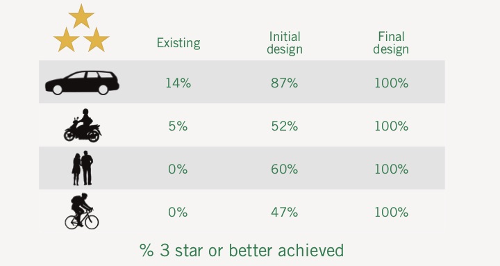
The Millennium Challenge Corporation (MCC) worked in partnership with the Government of El Salvador to deliver the US$101.6 million Coastal Highway Expansion Project. iRAP Star Rated the project’s detailed design drawings, proposed modifications that would improve safety for road users, particularly pedestrians and cyclists, then worked closely with the road authority and designers to improve the safety of subsequent design iterations. A safer road design was achieved particularly for vulnerable road users, lifting the original design from a largely 1-2 Star Rating, to a 2-5 Star Rating. It also lead to a better understanding within the road authority of road safety design principles.
Read more2018-03-012018
Slide11

Mexico’s National Road Network

LOCATION: MEXICO

Mexico’s road network spans 42,801kms. With a commitment to reduce fatalities and serious injuries, the Secretariat for Communications and Transport (SCT) partnered with iRAP to assess the safety of the asset and inform strategic investment to reduce casualty crashes. The SCT systematically Star Rated their road network in 2012, investing millions of pesos in iRAP recommended road upgrades. They resurveyed the network in 2015 to evaluate the success of their investment. The results highlighted that 17% of the 42,801km road network was lifted from only a 1 or 2-star level to 3-star or better.
Read more2018-03-012018
IRAP-SR4S-Case-Study-Bogota (1)-1

SR4S: Improved pedestrian facilities around IED Rodrigo Lara Bonilla (Bogota)

LOCATION: COLOMBIA

In 2018, the Bogota Mobility Secretariat launched their 2,000th safe school zone, around the IED Rodrigo Lara Bonilla Public School in Ciudad Bolivar.  The Mobility Secretariat used the Star Rating for Schools (SR4S) tool to provide an objective measure of risk and star rating performance at the existing location and to stimulate scenarios and measure star rating improvements associated with the implementation of a planned set of countermeasures. After countermeasures where implemented, the conditions around the school were then assessed using the SR4S app, which resulted in an improvement from 2- and 3-stars to 4- and 5-star safety.
Read more2019-08-122019
iRAP_SR4S_Iran_Case_Study (1)-1

SR4S: Improved pedestrian facilities at Shohada, Imam Ali & Azmoodeh Primary Schools (Tehran & Mashhad)

LOCATION: IRAN

In 2019, Road Safety Pioneers led life-saving safety improvements on school zones in Iran. Assessments were conducted around eight primary schools in Tehran and Mashhad using the SR4S app. Three schools were found to have a 1-star safety rating and were selected for the implementation of safety treatments. SR4S was again used to assess the school zones post-construction - the result was an improvement to 3-stars for the Shohada School, 4-stars for the Imam Ali School and 2-stars for the Azmoodeh School.
Read more2020-07-202020

The International Road Assessment Programme (iRAP) is a Registered Charity with UN ECOSOC Consultative Status.
iRAP is registered in England and Wales under company number 05476000
Charity number 1140357

Registered office: 60 Trafalgar Square, London, WC2N 5DS
GET IN TOUCH │ Europe │ Africa │ Asia Pacific │ Latin America and Caribbean │ North America

en_USEnglish
Share This