Main Roads Western Australia and Anditi have revolutionized road safety assessments with an approach which automatically detects road infrastructure data applied on 2,000km of roads across the State.
In their goal of Star Rating the safety of 80 per cent of the State’s most travelled roads, Main Roads WA partnered with iRAP and Anditi to design and develop a more automated, accurate and cost-effective solution for road assessment, to update roadside risk ratings and extract asset management data.
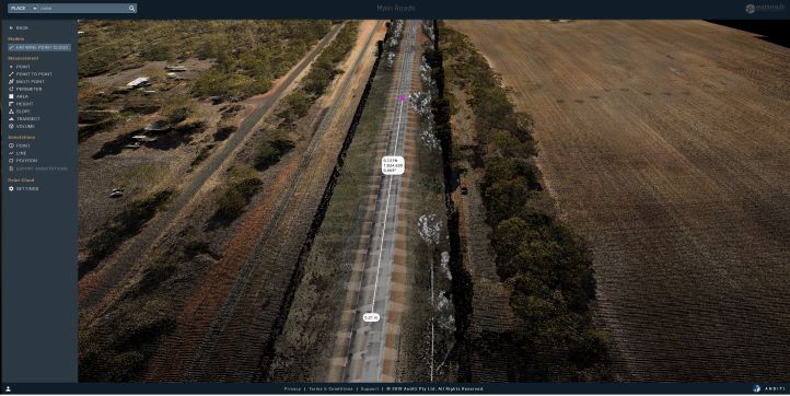
The project analysed 2,000kms of urban and rural roads using Anditi’s newly-developed Road.ai technology and 3D Web Portal. Road.ai and the 3D portal enable the automated extraction and visualization of road safety attribute and asset data from Mobile LiDAR and 360 Degree Imagery. The technology captured median type and width, roadside objects, centreline rumble strips, intersection types, street lighting, trees, and property access points.
Main Roads WA Project Manager Fritha Argus said, “Traditionally, road asset management has required road surveyors driving thousands of kilometres of road and recording videos and visually assessing roadside features.
“Working with iRAP and Anditi, we’ve been able to make the data collection process faster, more affordable, and importantly easily scalable across our network,” she said.
The approach, which meets AusRAP and iRAP Star Rating specifications, is estimated to reduce costs of data collection by approximately 50 per cent. It also improves workplace health and safety by eliminating the need for manual data collection along these roads.
Main Roads WA plan to expand the approach to meet road safety targets and manage and access their spatial data assets for evaluating maintenance requirements and compliance checks on an on-going basis.
The project comes at an important time for Australian road agencies. The draft National Road Safety Strategy 2021-2030 aims to reduce fatalities and serious injuries per capita by 50 per cent and 30 per cent respectively. Improving the safety of infrastructure planning and investment and regional roads are key Strategy priorities. The 2018-2020 National Road Safety Action Plan set targets for 90% of travel on national highways and 80% of travel on state highways to meet a 3-star or better safety standard by 2020.
Over 280,000km of AusRAP Star Rating assessments have already been undertaken by road agencies and mobility clubs across Australia.
iRAP Global Innovation Manager Monica Olyslagers said, “The automation of data capture that has been developed through this project has the potential to make routine, large scale safety Star Rating assessments and Fatality and Serious Injury Estimates an integral part of the road asset management process.
“With faster and more affordable data collection processes, safety assessments can be performed annually across the whole network to inform road safety improvements and state and national policy and investment decisions,” she said.
Between 1,100 and 1,200 people lose their lives to road crashes on Australian roads each year, and more than 40,000 suffer lifelong, debilitating injuries.
Hear Fritha, Monica and Peter Jamieson, Managing Director of Anditi present the results of this project and progress of the AiRAP Initiative at the 2021 Innovation Workshop on 7 and 14 October. With the theme “Data Driven Innovation to Halve Global Road Deaths by 2030”, the 2-day free Workshop is hosted by iRAP and the Regional Road Safety Observatories. For more information on the Workshop or to register, click here.
For more information:
- Project Lead – Fritha Argus, Research and Data Coordinator, Main Roads WA, fritha.argus@mainroads.wa.gov.au
- AiRAP Lead – Monica Olyslagers, iRAP Global Innovation Manager, monica.olyslagers@irap.org
- AiRAP Initiative – https://irap.org/project/ai-rap/
- 2021 Innovation Workshop – https://irap.org/2021/08/registration-open-2021-innovation-workshop-with-regional-road-safety-observatories-data-driven-innovation-to-save-lives/

LIDAR project images


