We are delighted to announce that the Australian firm Anditi has received AiRAP attribute accreditation for its methods to produce road attribute data from LiDAR and 360 degree imagery in accordance with iRAP specifications.
The new source data can be used to produce 34 road attributes for roads across Australia. Anditi developed and refined the data extraction methods based on road networks in Western Australia, New South Wales and Victoria.
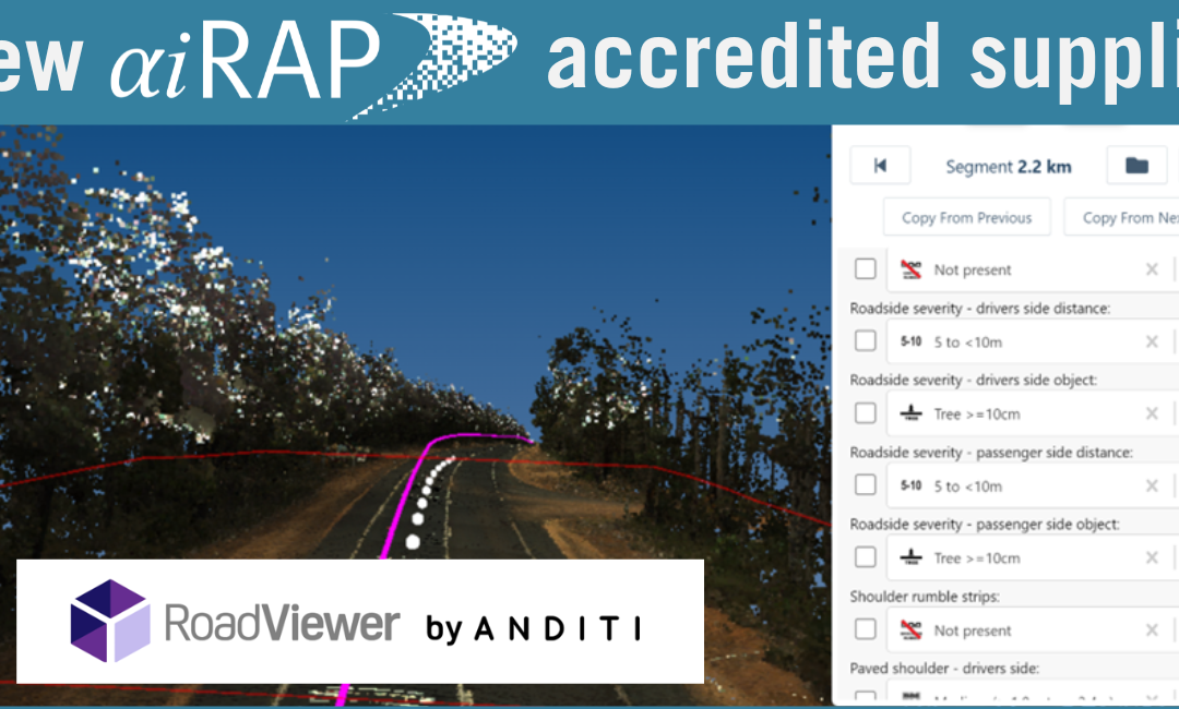
The AiRAP data can be used in conjunction with RoadViewer, Anditi’s accredited inspection system.
RoadViewer & AiRAP (Video).mp4 from Anditi on Vimeo.
For more information about the data, click here.
AiRAP accreditation is iRAP’s newest category of accreditation. It is specifically to certify the use of data derived from big data and/or machine-learning methods meets iRAP specifications. More information on AiRAP is available at www.irap.org/airap.
The AiRAP accreditation process is open to any data providers and is managed as part of iRAP’s broader accreditation program.
About Anditi
Founded in Australia in 2014, Anditi is a world-leading expert in extracting road safety attributes and road corridor asset information from remote sensing data. This is achieved using mobile and aerial LiDAR, and 360-degree, aerial and satellite imagery and our in-house software RoadViewer for data analysis, feature extraction and visualisation.
We have access to LiDAR and imagery for over 60 countries and work with a wide range of data capture providers.
Over the past 3 years we have worked closely with iRAP as it has developed and defined its Accelerated and Intelligent Road Assessment Program and are proud to be part of this significant achievement and its ability to reduce road deaths and injuries globally.
In addition to generating AiRAP Star Rating road assessments, RoadViewer can also be used to provide an array of other road corridor products and services, including asset management, bridge clearance and swept path analysis/collision detection for oversize vehicles. This assists in further unlocking the value and increasing the utilisation of the LiDAR and imagery dataset once captured.
This data can be provided in 2D and 3D formats that are compatible with iRAP VIDA Star Rating requirements and standard GIS/CAD package formats. Data can also be provided via our RoadViewer web portal, which is intuitive and simple to use. Roadviewer portal has been designed to import/export multiple file types, enable measurements and annotations and work seamlessly with other geospatial software. This provides an unparalleled combination of geospatial analytics and visualisation from any location.
More detail on Anditi can be found at www.anditi.com and www.roadviewer.com


