Bogotá, Colombia, is one of five cities in CycleRAP’s international pilot program.
Image credit: Jeffrey Greenberg/Universal Images Group, via Getty Images
After launching CycleRAP in 2022, in 2023 iRAP embarked on an international pilot project with the generous support Fundación MAPFRE PTV Group and Union Cycliste Internationale. We are so honoured to have the CycleRAP tool and pilots feature in the New York Times climate edition.
Click here to read the full article on NY Times or read below.
To Help Cyclists, and the Environment, This Tool Looks for Crashes
Sept. 20, 2023, 2:09 p.m. ET
This article is part of NYT special section on the Climate Forward event that will include policy and climate leaders from around the world.
An international pilot program is helping cities to identify and pinpoint high risk locations where cyclists and light-mobility users are likely to have collisions.
Over 20 years, Fayetteville, Ark., steadily built a 110-mile bicycle network of paved and natural-surface trails that today weaves through the city.
Now, the city in northwest Arkansas plans an ambitious expansion that by 2040 is expected to provide entry points to the trail network within a few minutes’ bike ride “from every resident and every rooftop,” said Brannon Pack, director of cycling tourism for Experience Fayetteville, the city’s official destination marketing organization. “If it’s not accessible, you’re going to be a lot less likely to utilize it as a form of transportation to minimize your carbon footprint.”
To help ensure the safety of its growing cycling infrastructure, Fayetteville city officials have turned to CycleRAP, a new risk-assessment tool designed to identify and pinpoint high-risk locations where cyclists and light-mobility users are likely to crash. (The terms light mobility and micro mobility are interchangeable, and refer to low-speed human or powered vehicles, like skateboards or e-bikes.)
“If we really want to make sure that urban mobility is sustainable into the future, and bicycling is part of that, safety is where it needs to start,” said Monica Olyslagers, who oversees CycleRAP for the International Road Assessment Programme (iRAP), a nonprofit that identifies high-risk roads in 128 countries.

Image and data collection in Fayetteville, Ark.
Image Credit: Experience Fayetteville
The goal of CycleRAP’s software model is to assist transport officials, policymakers and urban planners in addressing danger areas to prevent collisions that result in serious injury and death. Development began nearly 10 years ago, mostly focused in Europe, prompted by research about safety surrounding the proliferation of bicycles, e-bikes, scooters and other micro mobility, and the fact that up to 95 percent of hospitalizations internationally were due to crashes that didn’t involve a vehicle, according to reports in the journals Accident Analysis & Prevention and Injury Prevention.
“Bicycle crashes are underreported everywhere,” Ms. Olyslagers said, “even in the most advanced cycling cities and countries. Many cities struggle to accommodate these new road users in a safe way, but it’s hard when you don’t know where the crashes are happening and don’t have the data or the design know-how to come up with a solution.”
Like Fayetteville, many cities around the world grapple with how to offer greener, safer mobility choices. Finding solutions to climate change on a local level is one of the topics being discussed by leaders in business, science and policy during The New York Times Climate Forward event on Thursday.
Choosing a bike over a car just one trip a day reduces a person’s carbon footprint by about half a ton a year, and cyclists have 84 percent lower carbon dioxide emissions from all daily travel than noncyclists, said Jill Warren, chief executive of the European Cyclists’ Federation, quoting a recent report from the University of Oxford’s Transport Studies Unit. “But survey after survey will show that the No. 1 reason people give for not cycling or not cycling more will be that feeling of safety. The No. 1 thing that communities can do is to make cycling safer by creating the right infrastructure.”

Fayetteville plans an ambitious expansion that by 2040 is expected to provide entry points to the trail network within a few minutes’ bike ride “from every resident and every rooftop,” Brannon Pack said.
Image Credit: Experience Fayetteville
CycleRAP formally launched in 2022, and earlier this year presented at the International Transport Forum’s summit in Leipzig, Germany, on “Transport Enabling Sustainable Economies.” Fayetteville is one of five cities where the program is currently being evaluated as part of an international pilot program. The other four are Barcelona, Spain; Bogotá, Colombia; Madrid; and São Paulo, Brazil.
“The goal of the pilot is to showcase how CycleRAP can be used to meet the needs of people and cities globally,” said Ms. Olyslagers, including cost. “We estimate that for approximately 60 miles of a downtown area, such as Seattle, the current cost would be approximately $200 per mile,” for a total of $12,000. “Suppliers all over the world can work out what the local needs are, including language differences, and tailor their software tools.”
Cities identify where assessments should occur, then in frequent intervals, capture features of the roads and bike path, lanes and trails, including traffic speed and flow, via videos and data. Collection can be conducted by iRAP, suppliers (companies it trains) or by the cities themselves. ***
The collected information, which is from public spaces but with identifying features made anonymous, is then run through the CycleRAP software model by iRAP staff, or authorized companies, which calculates cyclists’ risk for four crash types: conflicts with vehicles; other bicycles (or light mobility); pedestrians; or an object. Each crash type risk is rated low, medium, high or extreme, and is mapped. Safety recommendations typically include measures like widening bike paths, installing lighting or lowering traffic speeds.
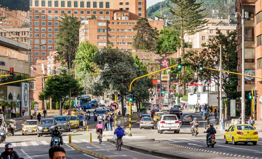
In the pilot cities, preliminary results indicated most overall risk was due to vehicle-bicycle conflicts. In Bogotá, high pedestrian flow on shared sidewalks and steep roads increased the likelihood of cyclists crashing with walkers or something in the terrain. Assessments in Barcelona and Madrid focused primarily on ways to improve how bike paths and lanes were connected overall.

Commuters in Bogotá.
Image Credit: Daniel Munoz/Agence France-Presse — Getty Images
In São Paulo, the city’s network “is not as safe as we expected it to be,” said Flavio Soares, project manager for Ciclocidade, a nonprofit association of local urban cyclists that helped the city build its strategic climate-action plan to include targets for cycling.
The city plans to expand its infrastructure to accommodate the growing number of cyclists — an expected more than four-fold increase by 2030 — “but goals are not enough,” Mr. Soares said.
A section of Consolação Street in São Paulo was rated as “extreme risk” for bicyclists being hit by vehicles that invade the cycle lane, including by Uber drivers picking up people, motorcyclists, or trucks unloading goods, Mr. Soares said. CycleRAP recommended removing parking, and including a protective barrier or making the infrastructure wider, or both.
Other pilot cities also are using CycleRAP to identify their own safety issues.
“We’ve seen some early data,” said Mr. Pack, who along with the city’s active transportation manager and the mobility coordinator, recorded almost 50 miles of Fayetteville’s network. “Close to 70 percent of our network will be categorized as low or medium risk. That’s good, but that also means that 30 percent of our network is likely to be rated at a high or extreme risk for conflict, so likely needs immediate or continued improvements. We have work to do.”
Final results from the pilot program will be presented at the Union Cycliste Internationale (UCI) Mobility and Bike City Forum in October in Bruges, Belgium, and used in workshops to help other cities improve safety.
In Fayetteville, the Active Transportation Advisory Committee, a citizen-led group, will review the findings and make formal recommendations to the city’s transportation and public-works staff, who decide what will be implemented.
CycleRAP can help cities prioritize policy and investment, said Mr. Pack, who expects funding improvements will not be an issue. “It’s community support that has led to the development of the network, and to empowering our elected officials to continue to invest year over year to make our bicycle network safer for everybody.”
“We’re a community of cyclists,” he added. “We treat cycling as just another core pillar of our community.”
– Article credit New York Times
***ERRATA: The original NYT erroneously mentioned that the community members did the assessments in Bogotá, but the city’s technical team members were involved in the data collection.


