Select Page

SLAIN Project -Saving Lives Assessing and Improving TEN-T Road Network Safety

Vision

Road safety in Europe has improved thanks to the different actions taken at European, national and local levels. Although some Member States continue to make considerable progress, EU-wide road fatality rates have stagnated in recent years.

To work towards the implementation of both the United Nations and European Commission goals on road safety and especially supporting authorities in the reporting requirements of the Directive 2008/96/EC on road infrastructure safety management, a more systematic approach to safer road infrastructure is needed.

EuroRAP is addressing this through a programme of systematic risk assessment and by identifying shortcomings that can be addressed by practical road improvement measures.


Objectives

The project’s Action fits in the EC’s 2010 Communication ‘Towards a European Road Safety Area’ and aims to contribute to the long-term goal for zero road deaths in 2050.

With partners in the different countries, Project SLAIN is a transnational project aiming to extend the skills and knowledge base of partners in performing network-wide road assessment.

The main areas to be covered within the SLAIN project are

  • Demonstration of a methodology of network-wide assessment
  • Assessment of the Safety Performance Management of the TEN-T core road network and, if possible beyond, in 4 European countries: Croatia, Italy, Greece and Spain where we will perform road surveys (10,000 km of mapping)
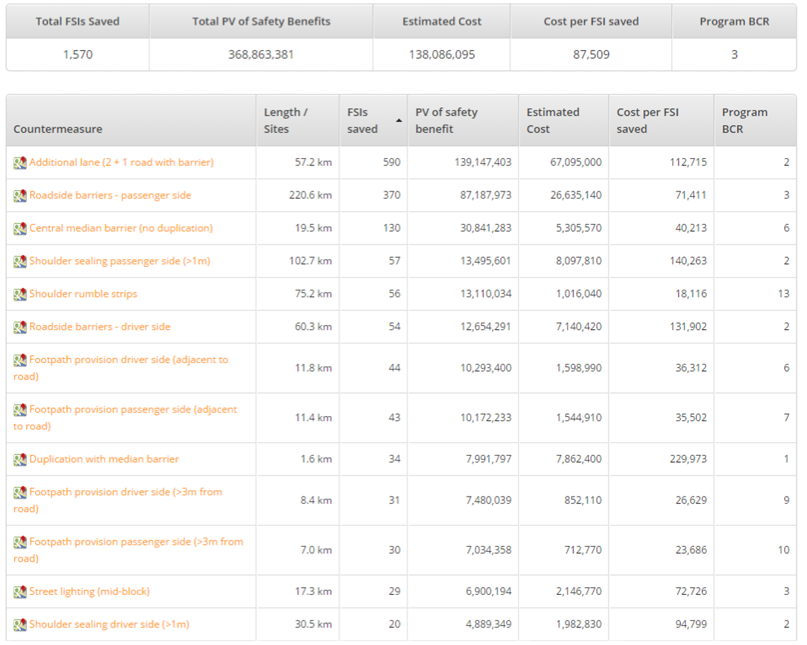
  • Proposals of section-specific, economically-viable crash countermeasures designed to raise infrastructure quality to achieve significant reductions in severe injuries and deaths
  • Preparation of the readiness of Europe’s physical infrastructure for automation

Partners

The SLAIN consortium consists of eight core partners, coming from six EU member states, namely Greece, Italy, Spain, Croatia, UK and Belgium. The objectives of SLAIN are covered in a collective way in this consortium. The partners have structured a solid, experienced, well-balanced and motivated consortium that will best accomplish the objectives set both by the RISM directive, as well as those set by the SLAIN project in all its stages. As far as the geographical spread and coverage of the consortium is concerned, the locations of the project partners are considered to be relevant for the successful execution of the SLAIN project and the further exploitation of its results.

List of partners: EuroRAP – Project Coordinator, Anas, FPZ, RSI Panos Mylonas, RACC-ACASA, DGT Spain, SCT Spain, TES Spain (Catalonia), iRAP


Project Structure

The project is set out in 8 activities to support and encourage the proposed changes to Directive 2008/96/EC and Prepare for Automation:

1. Risk Mapping.

Objective = to produce maps showing total risk as an overall part of network-wide road assessment. 

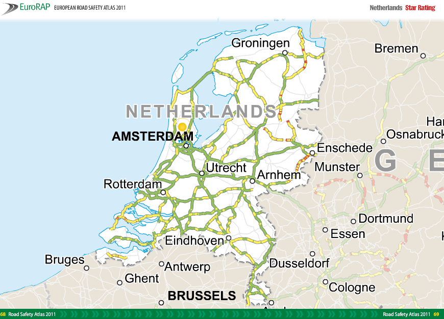
The task concerns the cartography relating crash data to traffic across the core TEN-T and if possible, the primary network in Croatia, Greece, Italy (on the core network of the Italian beneficiary ANAS) and Spain with particular attention to the Catalonian core road section. A Risk Map of death and serious injury will be produced for each country.

2. Star Rating.

Objective = the production of maps showing the total risk as an overall part of network-wide road assessment, together with investment plans. 

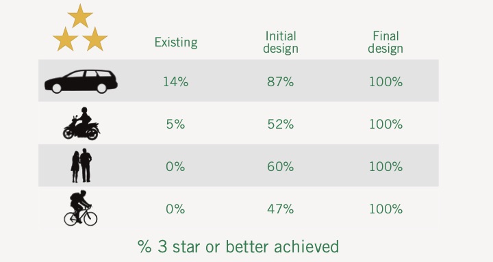
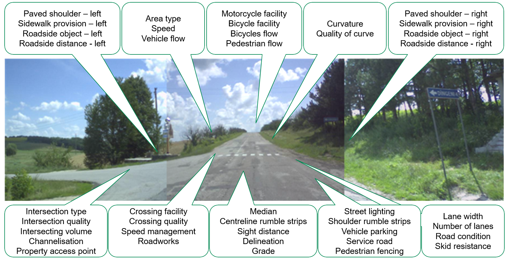
The work in this activity mainly involves the Road Survey and Data analysis leading to producing Star Ratings (SR) and Development of Safer Roads Investment Plans (SRIP).  As Greece has recent data, it will not repeat this exercise.  

3. Technical justification for network-wide road assessment

Objective = to compare network-wide road assessment alongside other methods providing information and know-how to countries who are yet to carry out network assessment.

There will be a review of different forms of network-wide road assessment and a comparison of these strategies with traditional “crash cluster” and “hot spot” approaches. This will use the data available from Greece and data from one or more other countries, subject to suitable data availability, to explain and provide a rationale for potential users of a network assessment approach.

4. “How to” guide for network-wide road assessment.

Objective = to build on material used in activity 3 to produce a step-by-step guide for the practitioner.

This is a guide which will explain the circumstances, data and steps required to perform a network-wide road assessment. It will be a document of approximately 20-30 pages presented in an easy-to-use and understand style that will be targeted particularly at policy-makers and those without first-hand engineering experience.

5. Global analysis of the safety of the TEN-T - research and mining of data from previous network-wide road assessment

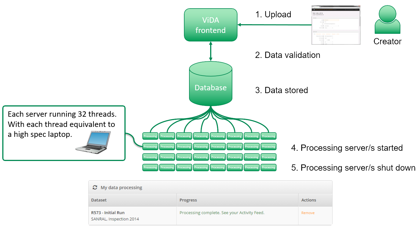
Objective = the production of a technical report. In particular, the report will include an analysis of road survey data for roads held in the iRAP ViDA data platform.

The purpose of this module is to provide to the European Commission a more formal estimate than previously available of the overall safety of the Core TEN-T and primary network and demonstrate what must be done to improve that.

secondary objective is that, using data from Greece, it will be possible to show the detailed applications now possible within ViDA.

6. Case studies using the application of network-wide road assessment

Objective= the collection of a series of approximately 100 examples or case studies in total using the five techniques (A-E).

Case Study A: Risk Mapping to guide selective Star Rating

Case Study B: Before and after studies of network upgrading

Case study C: Identifying road sections to install 2+1 barrier

Case study D: Maintenance-only remedies

Case study E: Network-wide road assessment and Star Rating from design plans

7. Preparing the physical infrastructure for automation

Objective= to perform a three-part study to show readiness of physical infrastructure for automation.

Preparing the physical infrastructure for automation stresses the importance of the readiness of the physical road infrastructure for automation which should gradually be complemented by digital infrastructure. 

Project management and dissemination of results.

Objective = to include continuous project management and communication and dissemination activities.

Expected outcomes

The project results comprise the means for enabling partners to accomplish a common view and approach in deploying road assessment tools and to build on the material to support the discussions of both Directive 2008/96/EC and CCAM Single Platform.

The SLAIN Consortium will validate a set of recommendations on the requirements for AVs with respect to Digital and Physical Infrastructure in the 4 member states. These results will be published in 2021.

Eventually, the SLAIN project will pave the way for future actions that will integrate Road Assessment Programmes in Europe, with a focus on saving lives.

Deliverables

Brochure:

Presentations:

D1.1 – Two maps for Croatia in 2020 and 2021 MS5.3 Technical report on the global budget for raising the entire TEN-T network to a higher level of safety
D1.2 – Two maps for Italy in 2020 and 2021 D6.1 Case Study A
D1.3 – Two maps for Greece in 2020 and 2021 D6.2 Case Study B
D1.4 – Two maps for Spain in 2020 and 2021 D6.3 Case Study C
D1.5 – Maps for Catalonia in 2020 and 2021 D6.4 Case Study D
D2.1 Star rating map for Italy D6.5 Case Study E
D2.2 Star rating map for Croatia D7.1 Report – Quality of horizontal and vertical signs – ‘Roads that cars can read’
D2.3 Report for Spain on tailoring the methodology to national and regional needs and how to improve and develop the methodology D7.2 Report – Other initiatives to meet the needs of automated cars
D2.4 Validation study with Spanish crash data and Star Rating data D7.3 Automatic coding methodology of the network for network wide road assessment & D7.4 Evaluation of improvements achieved with an automated coding methodology
D3.1 Report on the technical justification for network-wide road assessment D8.1 Project Management Handbook
D3.2 Flyer leaflet on the technical justification for network wide road assessment

D8.2 Newsletters

July 2019 – January 2020 – July 2020 – January 2021

D3.3 Webpage containing a summary of technical justification of network-wide road safety assessment and examples of the application of this tool within crash analysis D8.3 Recommendations towards the introduction of a network wide road safety approach
D4.1 A step by step guide D8.4 Project final conference

Contacts

Shona Holroyd
shona.holroyd@irap.org

Kate Fuller – Technical Coordinator
kate.fuller@roadsafetyfoundation.org

Link to Newsletter:
 section-specific, economically-viable crash countermeasures.

The International Road Assessment Programme (iRAP) is a Registered Charity with UN ECOSOC Consultative Status.
iRAP is registered in England and Wales under company number 05476000
Charity number 1140357

Registered office: 60 Trafalgar Square, London, WC2N 5DS
GET IN TOUCH │ Europe │ Africa │ Asia Pacific │ Latin America and Caribbean │ North America

en_USEnglish
Share This