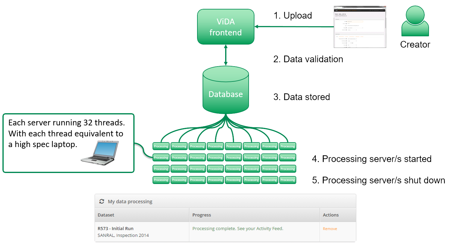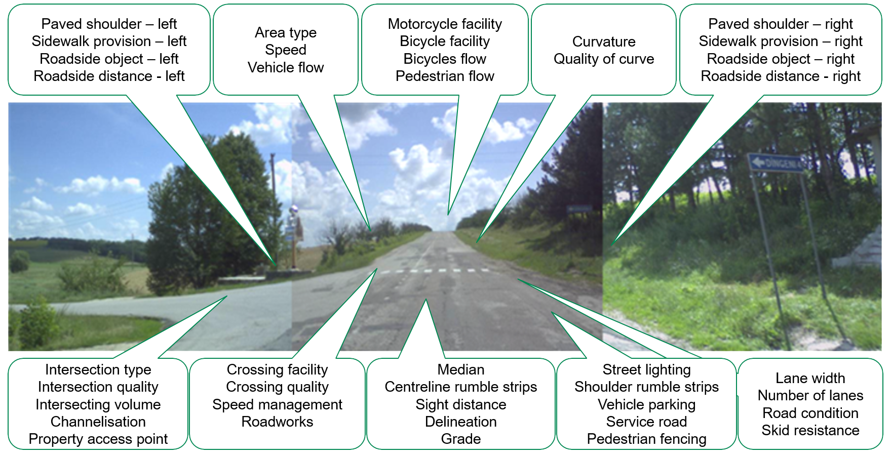
iRAP accreditation helps ensure that iRAP assessments are performed to the same consistently high level of quality worldwide. Practitioners that are accredited can become part of a market of practitioners/suppliers that are able to bid competitively to provide iRAP-specification services.
Four categories of iRAP accreditation
1. Activity accreditation is for individual practitioners who perform iRAP assessment activities.
2. Inspection system accreditation is for equipment and software used to perform iRAP surveys and road attribute coding.
3. AiRAP attribute accreditation is for data suppliers capable of automatically producing road attribute data for use in iRAP assessments.
4. AiRAP enabled inspection system accreditation, is for equipment and software that meets requirements for inspection system accreditation and AiRAP attribute accreditation.
Benefits of iRAP accreditation
- Formal acknowledgement that a practitioner can perform iRAP-specification activities.
- Formal acknowledgement that an inspection system is capable of being used to perform iRAP specifications.
- Listing on the iRAP website as an accredited practitioner. This listing is used regularly by organisations procuring iRAP-specification services, such as the World Bank.
- Join a community that is guided by the iRAP Accreditation Code of Conduct.
- License to use the iRAP Accredited logo.

Quick Links
Activity Accreditation
Four types of activity accreditation are available to individual practitioners:
- Road survey (described in the iRAP Survey Manual).
- Road Attribute Coding (described in the iRAP Coding Manual).
- Analysis and Reporting (described in the iRAP Star Rating and Investment Plan Manual).
- SR4S Quality Review (only by invitation)
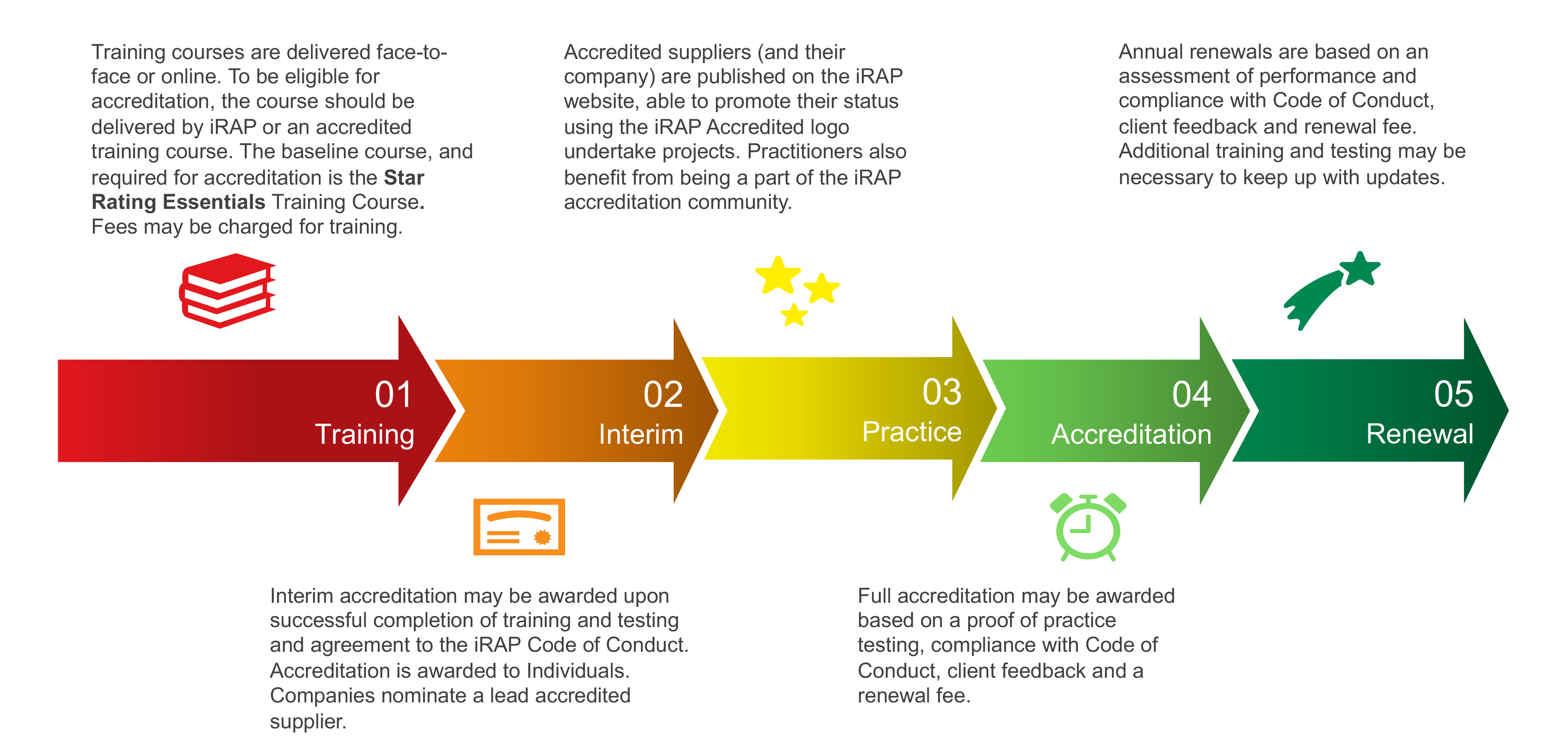
Practitioners that hold activity accreditation have completed training and successfully completed a test and have demonstrated experience. They have also signed the iRAP Accredited Supplier Code of Conduct. Activity accreditation is renewed annually based on demonstrated experience and may include refresher training and consideration of client feedback. Practitioners may hold one or more category of accreditation at a time.
The process activity accreditation is shown in the graphic below.
Accredited Practitioners
Search for an Accredited Practitioner below.
Accreditation of inspection systems
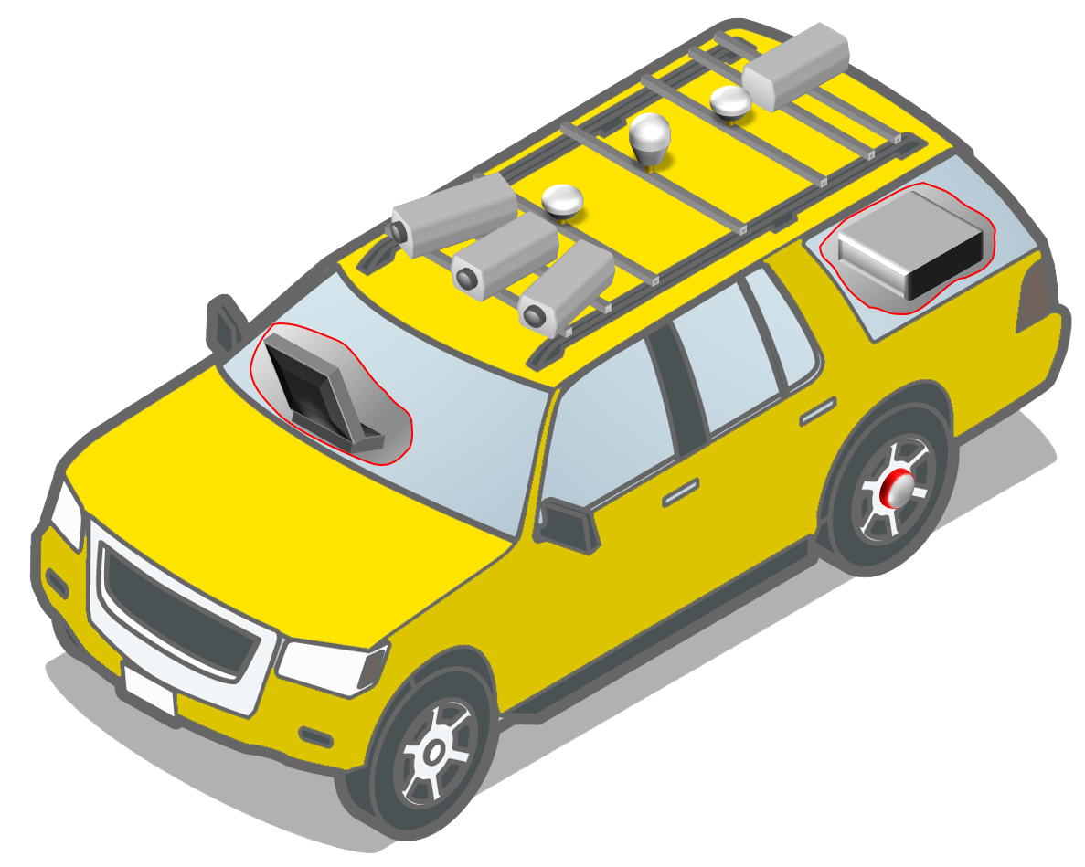
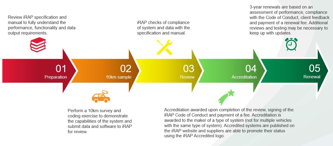
An accredited inspection system is capable of being used in the performance of survey activities described in iRAP Survey Manual and road attribute coding activities described in the iRAP Coding Manual.
The requirements for system accreditation are described in the iRAP Inspection System Accreditation Specification.
The process for accreditation of an inspection system is shown in the graphic below.
Accredited inspection systems
AiRAP attribute accreditation
AiRAP attribute accreditation is for the conversion (using AI or machine learning methods) of source data into iRAP attributes. It is compulsory for AiRAP attributes to be accredited before use in local and regional KPI reporting and iRAP assessments, unless the data is collected in a project is designated as a ‘pilot’ (and in which accreditation will be attained as part of the pilot project). For more information about the AiRAP attribute accreditation process, see the document titled, AiRAP Attribute Accreditation Process.
AiRAP -enabled inspection systems
AiRAP-enabled inspection systems meet requirements for inspection system accreditation and AiRAP attribute accreditation. They must be capable of automatically integrating AiRAP attribute data into the inspection system.
Accredited AiRAP data suppliers
Accredited AiRAP data suppliers are listed below. Each supplier is capable of producing data for the attributes and regions listed in accordance with the iRAP Coding Manual.
| Supplier | Attribute | Region/s | Road type | Data source | Level of Accreditation (click on the '+' for more information/AiRAP data supplier details) | Level of Accreditation information | Additional information |
|---|---|---|---|---|---|---|---|
| Anditi Pty Ltd | Median type | Australia. Other regions subject to iRAP review. | Specific - Net 2 Class 1-4 (Roads of international, national, regional importance, and local roads of high importance.) | LiDAR and 360 imagery (supplied by TomTom Mobile Mapping) | Level 3 | Level 3: There are no limitations on the use of the data for iRAP applications. It is suitable for network screening, light data approaches, KPI reporting, Star Ratings, Fatality Estimations and Investment Plans. | Download Accredited AiRAP data supplier details > |
| Anditi Pty Ltd | Roadside severity – object (driver side/passenger side) | Australia | Specific - Net 2 Class 1-4 (Roads of international, national, regional importance, and local roads of high importance.) | LiDAR and 360 imagery (supplied by TomTom Mobile Mapping) | Level 3 | Level 3: There are no limitations on the use of the data for iRAP applications. It is suitable for network screening, light data approaches, KPI reporting, Star Ratings, Fatality Estimations and Investment Plans. | Download Accredited AiRAP data supplier details > |
| Anditi Pty Ltd | Paved shoulder (driver side/passenger side) | Australia | Specific - Net 2 Class 1-4 (Roads of international, national, regional importance, and local roads of high importance.) | LiDAR and 360 imagery (supplied by TomTom Mobile Mapping) | Level 3 | Level 3: There are no limitations on the use of the data for iRAP applications. It is suitable for network screening, light data approaches, KPI reporting, Star Ratings, Fatality Estimations and Investment Plans. | Download Accredited AiRAP data supplier details > |
| Anditi Pty Ltd | Intersection type | Australia | Specific - Net 2 Class 1-4 (Roads of international, national, regional importance, and local roads of high importance.) | LiDAR and 360 imagery (supplied by TomTom Mobile Mapping) | Level 3 | Level 3: There are no limitations on the use of the data for iRAP applications. It is suitable for network screening, light data approaches, KPI reporting, Star Ratings, Fatality Estimations and Investment Plans. | Download Accredited AiRAP data supplier details > |
| Anditi Pty Ltd | Number of lanes | Australia | Specific - Net 2 Class 1-4 (Roads of international, national, regional importance, and local roads of high importance.) | LiDAR and 360 imagery (supplied by TomTom Mobile Mapping) | Level 3 | Level 3: There are no limitations on the use of the data for iRAP applications. It is suitable for network screening, light data approaches, KPI reporting, Star Ratings, Fatality Estimations and Investment Plans. | Download Accredited AiRAP data supplier details > |
| Anditi Pty Ltd | Lane width | Australia | Specific - Net 2 Class 1-4 (Roads of international, national, regional importance, and local roads of high importance.) | LiDAR and 360 imagery (supplied by TomTom Mobile Mapping) | Level 3 | Level 3: There are no limitations on the use of the data for iRAP applications. It is suitable for network screening, light data approaches, KPI reporting, Star Ratings, Fatality Estimations and Investment Plans. | Download Accredited AiRAP data supplier details > |
| Anditi Pty Ltd | Speed limit | Australia | Specific - Net 2 Class 1-4 (Roads of international, national, regional importance, and local roads of high importance.) | LiDAR and 360 imagery (supplied by TomTom Mobile Mapping) | Level 3 | Level 3: There are no limitations on the use of the data for iRAP applications. It is suitable for network screening, light data approaches, KPI reporting, Star Ratings, Fatality Estimations and Investment Plans. | Download Accredited AiRAP data supplier details > |
| Anditi Pty Ltd | Speed management | Australia | Specific - Net 2 Class 1-4 (Roads of international, national, regional importance, and local roads of high importance.) | LiDAR and 360 imagery (supplied by TomTom Mobile Mapping) | Level 3 | Level 3: There are no limitations on the use of the data for iRAP applications. It is suitable for network screening, light data approaches, KPI reporting, Star Ratings, Fatality Estimations and Investment Plans. | Download Accredited AiRAP data supplier details > |
| Anditi Pty Ltd | Curvature | Australia | Specific - Net 2 Class 1-4 (Roads of international, national, regional importance, and local roads of high importance.) | LiDAR and 360 imagery (supplied by TomTom Mobile Mapping) | Level 3 | Level 3: There are no limitations on the use of the data for iRAP applications. It is suitable for network screening, light data approaches, KPI reporting, Star Ratings, Fatality Estimations and Investment Plans. | Download Accredited AiRAP data supplier details > |
| Anditi Pty Ltd | Skid resistance | Australia | Specific - Net 2 Class 1-4 (Roads of international, national, regional importance, and local roads of high importance.) | LiDAR and 360 imagery (supplied by TomTom Mobile Mapping) | Level 3 | Level 3: There are no limitations on the use of the data for iRAP applications. It is suitable for network screening, light data approaches, KPI reporting, Star Ratings, Fatality Estimations and Investment Plans. | Download Accredited AiRAP data supplier details > |
| Anditi Pty Ltd | Road condition | Australia | Specific - Net 2 Class 1-4 (Roads of international, national, regional importance, and local roads of high importance.) | LiDAR and 360 imagery (supplied by TomTom Mobile Mapping) | Level 3 | Level 3: There are no limitations on the use of the data for iRAP applications. It is suitable for network screening, light data approaches, KPI reporting, Star Ratings, Fatality Estimations and Investment Plans. | Download Accredited AiRAP data supplier details > |
| Anditi Pty Ltd | Vehicle parking | Australia | Specific - Net 2 Class 1-4 (Roads of international, national, regional importance, and local roads of high importance.) | LiDAR and 360 imagery (supplied by TomTom Mobile Mapping) | Level 3 | Level 3: There are no limitations on the use of the data for iRAP applications. It is suitable for network screening, light data approaches, KPI reporting, Star Ratings, Fatality Estimations and Investment Plans. | Download Accredited AiRAP data supplier details > |
| Anditi Pty Ltd | Grade | Australia | Specific - Net 2 Class 1-4 (Roads of international, national, regional importance, and local roads of high importance.) | LiDAR and 360 imagery (supplied by TomTom Mobile Mapping) | Level 3 | Level 3: There are no limitations on the use of the data for iRAP applications. It is suitable for network screening, light data approaches, KPI reporting, Star Ratings, Fatality Estimations and Investment Plans. | Download Accredited AiRAP data supplier details > |
| Anditi Pty Ltd | Sight distance | Australia | Specific - Net 2 Class 1-4 (Roads of international, national, regional importance, and local roads of high importance.) | LiDAR and 360 imagery (supplied by TomTom Mobile Mapping) | Level 3 | Level 3: There are no limitations on the use of the data for iRAP applications. It is suitable for network screening, light data approaches, KPI reporting, Star Ratings, Fatality Estimations and Investment Plans. | Download Accredited AiRAP data supplier details > |
| Anditi Pty Ltd | Delineation | Australia | Specific - Net 2 Class 1-4 (Roads of international, national, regional importance, and local roads of high importance.) | LiDAR and 360 imagery (supplied by TomTom Mobile Mapping) | Level 3 | Level 3: There are no limitations on the use of the data for iRAP applications. It is suitable for network screening, light data approaches, KPI reporting, Star Ratings, Fatality Estimations and Investment Plans. | Download Accredited AiRAP data supplier details > |
| Anditi Pty Ltd | Street lighting | Australia | Specific - Net 2 Class 1-4 (Roads of international, national, regional importance, and local roads of high importance.) | LiDAR and 360 imagery (supplied by TomTom Mobile Mapping) | Level 3 | Level 3: There are no limitations on the use of the data for iRAP applications. It is suitable for network screening, light data approaches, KPI reporting, Star Ratings, Fatality Estimations and Investment Plans. | Download Accredited AiRAP data supplier details > |
| Anditi Pty Ltd | Centreline rumble strips | Australia | Specific - Net 2 Class 1-4 (Roads of international, national, regional importance, and local roads of high importance.) | LiDAR and 360 imagery (supplied by TomTom Mobile Mapping) | Level 3 | Level 3: There are no limitations on the use of the data for iRAP applications. It is suitable for network screening, light data approaches, KPI reporting, Star Ratings, Fatality Estimations and Investment Plans. | Download Accredited AiRAP data supplier details > |
| Anditi Pty Ltd | Shoulder rumble strips | Australia | Specific - Net 2 Class 1-4 (Roads of international, national, regional importance, and local roads of high importance.) | LiDAR and 360 imagery (supplied by TomTom Mobile Mapping) | Level 3 | Level 3: There are no limitations on the use of the data for iRAP applications. It is suitable for network screening, light data approaches, KPI reporting, Star Ratings, Fatality Estimations and Investment Plans. | Download Accredited AiRAP data supplier details > |
| Anditi Pty Ltd | Intersection channelization | Australia | Specific - Net 2 Class 1-4 (Roads of international, national, regional importance, and local roads of high importance.) | LiDAR and 360 imagery (supplied by TomTom Mobile Mapping) | Level 3 | Level 3: There are no limitations on the use of the data for iRAP applications. It is suitable for network screening, light data approaches, KPI reporting, Star Ratings, Fatality Estimations and Investment Plans. | Download Accredited AiRAP data supplier details > |
| Anditi Pty Ltd | Property access points | Australia | Specific - Net 2 Class 1-4 (Roads of international, national, regional importance, and local roads of high importance.) | LiDAR and 360 imagery (supplied by TomTom Mobile Mapping) | Level 3 | Level 3: There are no limitations on the use of the data for iRAP applications. It is suitable for network screening, light data approaches, KPI reporting, Star Ratings, Fatality Estimations and Investment Plans. | Download Accredited AiRAP data supplier details > |
| Anditi Pty Ltd | Land use (driver side/passenger side) | Australia | Specific - Net 2 Class 1-4 (Roads of international, national, regional importance, and local roads of high importance.) | LiDAR and 360 imagery (supplied by TomTom Mobile Mapping) | Level 3 | Level 3: There are no limitations on the use of the data for iRAP applications. It is suitable for network screening, light data approaches, KPI reporting, Star Ratings, Fatality Estimations and Investment Plans. | Download Accredited AiRAP data supplier details > |
| Anditi Pty Ltd | Area type | Australia | Specific - Net 2 Class 1-4 (Roads of international, national, regional importance, and local roads of high importance.) | LiDAR and 360 imagery (supplied by TomTom Mobile Mapping) | Level 3 | Level 3: There are no limitations on the use of the data for iRAP applications. It is suitable for network screening, light data approaches, KPI reporting, Star Ratings, Fatality Estimations and Investment Plans. | Download Accredited AiRAP data supplier details > |
| Anditi Pty Ltd | Pedestrian crossing facilities (inspected road/side road) | Australia | Specific - Net 2 Class 1-4 (Roads of international, national, regional importance, and local roads of high importance.) | LiDAR and 360 imagery (supplied by TomTom Mobile Mapping) | Level 3 | Level 3: There are no limitations on the use of the data for iRAP applications. It is suitable for network screening, light data approaches, KPI reporting, Star Ratings, Fatality Estimations and Investment Plans. | Download Accredited AiRAP data supplier details > |
| Anditi Pty Ltd | Pedestrian fencing | Australia | Specific - Net 2 Class 1-4 (Roads of international, national, regional importance, and local roads of high importance.) | LiDAR and 360 imagery (supplied by TomTom Mobile Mapping) | Level 3 | Level 3: There are no limitations on the use of the data for iRAP applications. It is suitable for network screening, light data approaches, KPI reporting, Star Ratings, Fatality Estimations and Investment Plans. | Download Accredited AiRAP data supplier details > |
| Anditi Pty Ltd | Sidewalk (driver side/passenger side) | Australia | Specific - Net 2 Class 1-4 (Roads of international, national, regional importance, and local roads of high importance.) | LiDAR and 360 imagery (supplied by TomTom Mobile Mapping) | Level 3 | Level 3: There are no limitations on the use of the data for iRAP applications. It is suitable for network screening, light data approaches, KPI reporting, Star Ratings, Fatality Estimations and Investment Plans. | Download Accredited AiRAP data supplier details > |
| Anditi Pty Ltd | School zone warning | Australia | Specific - Net 2 Class 1-4 (Roads of international, national, regional importance, and local roads of high importance.) | LiDAR and 360 imagery (supplied by TomTom Mobile Mapping) | Level 3 | Level 3: There are no limitations on the use of the data for iRAP applications. It is suitable for network screening, light data approaches, KPI reporting, Star Ratings, Fatality Estimations and Investment Plans. | Download Accredited AiRAP data supplier details > |
| Anditi Pty Ltd | Roadworks | Australia | Specific - Net 2 Class 1-4 (Roads of international, national, regional importance, and local roads of high importance.) | LiDAR and 360 imagery (supplied by TomTom Mobile Mapping) | Level 3 | Level 3: There are no limitations on the use of the data for iRAP applications. It is suitable for network screening, light data approaches, KPI reporting, Star Ratings, Fatality Estimations and Investment Plans. | Download Accredited AiRAP data supplier details > |
| Agilysis Ltd | Vehicle flow (AADT) | Global | Rural areas (includes inter-urban roads and highways) | Earth Observation (EO) data | Level 2 | Level 2: Due to limitations, the data should be used with caution (or in conjunction with additional data) for iRAP applications. It is suitable for network screening, light data approaches, KPI reporting, and in some cases, Star Ratings and Fatality Estimations. | Download Accredited AiRAP data supplier details > |
| Agilysis Ltd | Operating Speed (85th percentile) | Global | Rural areas (includes inter-urban roads and highways) | Earth Observation (EO) data | Level 3 | Level 3: There are no limitations on the use of the data for iRAP applications. It is suitable for network screening, light data approaches, KPI reporting, Star Ratings, Fatality Estimations and Investment Plans. | Download Accredited AiRAP data supplier details > |
| Agilysis Ltd | Operating Speed (mean) | Global | Rural areas (includes inter-urban roads and highways) | Earth Observation (EO) data | Level 3 | Level 3: There are no limitations on the use of the data for iRAP applications. It is suitable for network screening, light data approaches, KPI reporting, Star Ratings, Fatality Estimations and Investment Plans. | Download Accredited AiRAP data supplier details > |
| Anditi Pty Ltd | Roadside severity – object (driver side/passenger side) | Australia | Specific - Net 2 Class 1-4 (Roads of international, national, regional importance, and local roads of high importance.) | LiDAR and 360 imagery (supplied by TomTom Mobile Mapping) | Level 3 | Level 3: There are no limitations on the use of the data for iRAP applications. It is suitable for network screening, light data approaches, KPI reporting, Star Ratings, Fatality Estimations and Investment Plans. | Download Accredited AiRAP data supplier details > |
| TomTom | Differential speed | Global (*All countries where data is available) | Specific - Net 2 Class 1-4 (Roads of international, national, regional importance, and local roads of high importance.) | TomTom MN-R data | Level 3 | Level 3: There are no limitations on the use of the data for iRAP applications. It is suitable for network screening, light data approaches, KPI reporting, Star Ratings, Fatality Estimations and Investment Plans. | Download Accredited AiRAP data supplier details > |
| TomTom | Speed limit | Global (*All countries where data is available) | Specific - Net 2 Class 1-4 (Roads of international, national, regional importance, and local roads of high importance.) | TomTom MN-R data | Level 3 | Level 3: There are no limitations on the use of the data for iRAP applications. It is suitable for network screening, light data approaches, KPI reporting, Star Ratings, Fatality Estimations and Investment Plans. | Download Accredited AiRAP data supplier details > |
| TomTom | Number of lanes | Global (*All countries where data is available) | Specific - Net 2 Class 1-4 (Roads of international, national, regional importance, and local roads of high importance.) | TomTom MN-R data | Level 3 | Level 3: There are no limitations on the use of the data for iRAP applications. It is suitable for network screening, light data approaches, KPI reporting, Star Ratings, Fatality Estimations and Investment Plans. | Download Accredited AiRAP data supplier details > |
| TomTom | Curvature | Global (*All countries where data is available) | Specific - Net 2 Class 1-4 (Roads of international, national, regional importance, and local roads of high importance.) | TomTom MN-R data | Level 3 | Level 3: There are no limitations on the use of the data for iRAP applications. It is suitable for network screening, light data approaches, KPI reporting, Star Ratings, Fatality Estimations and Investment Plans. | Download Accredited AiRAP data supplier details > |
| TomTom | Grade | Global (*All countries where data is available) | Specific - Net 2 Class 1-4 (Roads of international, national, regional importance, and local roads of high importance.) | TomTom MN-R data | Level 3 | Level 3: There are no limitations on the use of the data for iRAP applications. It is suitable for network screening, light data approaches, KPI reporting, Star Ratings, Fatality Estimations and Investment Plans. | Download Accredited AiRAP data supplier details > |
| TomTom | School zone warning | Global (*All countries where data is available) | Specific - Net 2 Class 1-4 (Roads of international, national, regional importance, and local roads of high importance.) | TomTom MN-R data | Level 3 | Level 3: There are no limitations on the use of the data for iRAP applications. It is suitable for network screening, light data approaches, KPI reporting, Star Ratings, Fatality Estimations and Investment Plans. | Download Accredited AiRAP data supplier details > |
| TomTom | Skid resistance | Global (*All countries where data is available) | Specific - Net 2 Class 1-4 (Roads of international, national, regional importance, and local roads of high importance.) | TomTom MN-R data | Level 1 | Level 1: There are limitations on the use of the data for iRAP applications. Due to limitations, the data is not suitable for all iRAP applications. It is suitable for network screening, light data approaches and KPI reporting. | Download Accredited AiRAP data supplier details > |
| Transoft | Upgrade cost | Global (*All countries where data is available) | Rural roads | Open data and 360 imagery | Level 3 | Level 3: There are no limitations on the use of the data for iRAP applications. It is suitable for network screening, light data approaches, KPI reporting, Star Ratings, Fatality Estimations and Investment Plans. | |
| Transoft | Motorcycle observed flow | Global (*All countries where data is available) | All roads | Open data and 360 imagery | Level 3 | Level 3: There are no limitations on the use of the data for iRAP applications. It is suitable for network screening, light data approaches, KPI reporting, Star Ratings, Fatality Estimations and Investment Plans. | |
| Transoft | Bicycle observed flow | Global (*All countries where data is available) | All roads | Open data and 360 imagery | Level 3 | Level 3: There are no limitations on the use of the data for iRAP applications. It is suitable for network screening, light data approaches, KPI reporting, Star Ratings, Fatality Estimations and Investment Plans. | |
| Transoft | Number of lanes | Global (*All countries where data is available) | All roads | Open data and 360 imagery | Level 3 | Level 3: There are no limitations on the use of the data for iRAP applications. It is suitable for network screening, light data approaches, KPI reporting, Star Ratings, Fatality Estimations and Investment Plans. | |
| Transoft | Curvature | Global (*All countries where data is available) | All roads | Open data and 360 imagery | Level 2 | Level 2: Due to limitations, the data should be used with caution (or in conjunction with additional data) for iRAP applications. It is suitable for network screening, light data approaches, KPI reporting, and in some cases, Star Ratings and Fatality Estimations. | |
| Transoft | Street lighting | Global (*All countries where data is available) | All roads | Open data and 360 imagery | Level 2 | Level 2: Due to limitations, the data should be used with caution (or in conjunction with additional data) for iRAP applications. It is suitable for network screening, light data approaches, KPI reporting, and in some cases, Star Ratings and Fatality Estimations. | |
| Transoft | Pedestrian crossing facilities (partial) | Global (*All countries where data is available) | Rural roads | Open data and 360 imagery | Level 2 | Level 2: Due to limitations, the data should be used with caution (or in conjunction with additional data) for iRAP applications. It is suitable for network screening, light data approaches, KPI reporting, and in some cases, Star Ratings and Fatality Estimations. | |
| Transoft | Roadworks | Global (*All countries where data is available) | All roads | Open data and 360 imagery | Level 3 | Level 3: There are no limitations on the use of the data for iRAP applications. It is suitable for network screening, light data approaches, KPI reporting, Star Ratings, Fatality Estimations and Investment Plans. | |
| Transoft | School zone warning | Global (*All countries where data is available) | All roads | Open data and 360 imagery | Level 3 | Level 3: There are no limitations on the use of the data for iRAP applications. It is suitable for network screening, light data approaches, KPI reporting, Star Ratings, Fatality Estimations and Investment Plans. | |
| Transoft | School zone crossing supervisor | Global (*All countries where data is available) | All roads | Open data and 360 imagery | Level 3 | Level 3: There are no limitations on the use of the data for iRAP applications. It is suitable for network screening, light data approaches, KPI reporting, Star Ratings, Fatality Estimations and Investment Plans. | |
| Transoft | Truck speed limit | Global (*All countries where data is available) | All roads | Open data and 360 imagery | Level 3 | Level 3: There are no limitations on the use of the data for iRAP applications. It is suitable for network screening, light data approaches, KPI reporting, Star Ratings, Fatality Estimations and Investment Plans. | |
| Transoft | Land use – Passenger-side | Global (*All countries where data is available) | All roads | Open data and 360 imagery | Level 2 | Level 2: Due to limitations, the data should be used with caution (or in conjunction with additional data) for iRAP applications. It is suitable for network screening, light data approaches, KPI reporting, and in some cases, Star Ratings and Fatality Estimations. This attribute is related to general area rather than specific to the passenger-side | |
| Transoft | Vehicle parking | Global (*All countries where data is available) | All roads | Open data and 360 imagery | Level 2 | Level 2: Due to limitations, the data should be used with caution (or in conjunction with additional data) for iRAP applications. It is suitable for network screening, light data approaches, KPI reporting, and in some cases, Star Ratings and Fatality Estimations. | |
| Transoft | Facilities for bicycles (partial) | Global (*All countries where data is available) | All roads | Open data and 360 imagery | Level 2 | Level 2: Due to limitations, the data should be used with caution (or in conjunction with additional data) for iRAP applications. It is suitable for network screening, light data approaches, KPI reporting, and in some cases, Star Ratings and Fatality Estimations. | |
| Transoft | Area type | Global (*All countries where data is available) | All roads | Open data and 360 imagery | Level 3 | Level 3: There are no limitations on the use of the data for iRAP applications. It is suitable for network screening, light data approaches, KPI reporting, Star Ratings, Fatality Estimations and Investment Plans. | |
| Transoft | Motorcycle speed limit | Global (*All countries where data is available) | All roads | Open data and 360 imagery | Level 3 | Level 3: There are no limitations on the use of the data for iRAP applications. It is suitable for network screening, light data approaches, KPI reporting, Star Ratings, Fatality Estimations and Investment Plans. | |
| Transoft | Differential speed limits | Global (*All countries where data is available) | All roads | Open data and 360 imagery | Level 3 | Level 3: There are no limitations on the use of the data for iRAP applications. It is suitable for network screening, light data approaches, KPI reporting, Star Ratings, Fatality Estimations and Investment Plans. | |
| Transoft | Land use – Driver-side | Global (*All countries where data is available) | All roads | Open data and 360 imagery | Level 2 | Level 2: Due to limitations, the data should be used with caution (or in conjunction with additional data) for iRAP applications. It is suitable for network screening, light data approaches, KPI reporting, and in some cases, Star Ratings and Fatality Estimations. This attribute is related to general area rather than specific to the driver-side | |
| Transoft | Speed management | Global (*All countries where data is available) | All roads | Open data and 360 imagery | Level 3 | Level 3: There are no limitations on the use of the data for iRAP applications. It is suitable for network screening, light data approaches, KPI reporting, Star Ratings, Fatality Estimations and Investment Plans. | |
| Transoft | Speed limit | Global (*All countries where data is available) | All roads | Open data and 360 imagery | Level 3 | Level 3: There are no limitations on the use of the data for iRAP applications. It is suitable for network screening, light data approaches, KPI reporting, Star Ratings, Fatality Estimations and Investment Plans. | |
| The Floow Ltd. | Operating Speeds (85th percentile, mean) | Global (*All countries where data is available) | All roads | Telemetry captured by On-Board Diagnostic (OBD) devices or smartphones | Level 3 | Level 3: There are no limitations on the use of the data for iRAP applications. It is suitable for network screening, light data approaches, KPI reporting, Star Ratings, Fatality Estimations and Investment Plans. | |
| The Floow Ltd. | Vehicle Flow (AADT) | Global (*All countries where data is available) | All roads | Telemetry captured by On-Board Diagnostic (OBD) devices or smartphones | Level 3 | Level 3: There are no limitations on the use of the data for iRAP applications. It is suitable for network screening, light data approaches, KPI reporting, Star Ratings, Fatality Estimations and Investment Plans. | |
| The Floow Ltd. | Speed Data (Mean) | Global (*All countries where data is available) | All roads | Telemetry captured by On-Board Diagnostic (OBD) devices or smartphones | Level 3 | Level 3: There are no limitations on the use of the data for iRAP applications. It is suitable for network screening, light data approaches, KPI reporting, Star Ratings, Fatality Estimations and Investment Plans. | |
| The Floow Ltd. | Intersecting road volume (categories) | Global (*All countries where data is available) | All roads | Telemetry captured by On-Board Diagnostic (OBD) devices or smartphones | Level 3 | Level 3: There are no limitations on the use of the data for iRAP applications. It is suitable for network screening, light data approaches, KPI reporting, Star Ratings, Fatality Estimations and Investment Plans. |
Apply for accreditation
To apply for iRAP activity or inspection system accreditation, please complete the standard application form.
The time required to achieve accreditation varies. The process may take months if extensive training or development work is required, or just a couple of weeks for experienced practitioners and well-developed systems.
Fees
| Type | Country | Fee (USD) | Renewal period | Renewal fee (USD) |
|---|---|---|---|---|
| Individual practitioners * | High income | 300 | 1 year | 300 |
| Individual practitioners * | Not high income | 150 | 1 year | 150 |
| Inspection system (survey and coding) | All | 9,750 | 3 years | 4,875 |
| AiRAP ≤10 / >10 attributes | All | 9,600 / 14,400 | 3 years | 4,800 / 7,200 |
| AiRAP-enabled inspection system ≤10 / >10 attributes | All | 13,550 / 15,950 | 3 years | 6,775 / 7,975 |
* A practitioner will pay a maximum of USD 200 (or USD 100), regardless of the number of types of accreditation they hold.
For more information
For more information about training, please contact Franco Azzato, iRAP Training and Accreditation Lead, training@irap.org.
