In urban environments worldwide, cycling is a critical mode of transport, offering sustainability, affordability, and health benefits. Despite its importance, traditional mobility models have largely focused on motorised transport, leaving a gap in understanding where and how people travel by bicycle. Recognising this need, ‘DOK data & road safety’ has developed an innovative approach to mapping cycling travel in support of the UN Road Safety Target 4, which is that roads carrying 75% of travel for each road user meet the 3-star or better global safety standard by 2030. The innovation illuminates where targeted risk assessments and infrastructure improvements can be cost-effectively applied with greatest safety impact.
Addressing the 75% Urban Cycling Reality
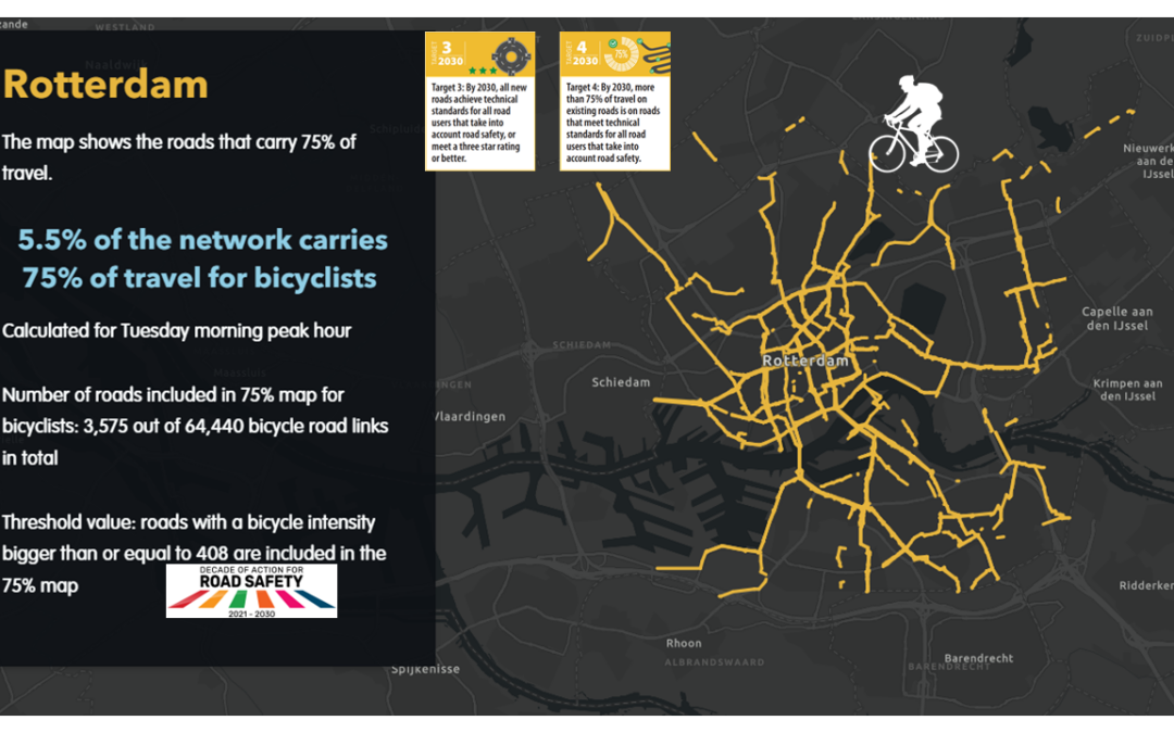
Where 75% of bicycle travel takes place in cities can help municipalities better manage the risks in locations where cyclists are most exposed to them. While conventional traffic models often overlook non-motorised users, this new approach places cyclists at the heart of mobility analysis, ensuring their travel patterns are accurately captured and integrated into urban planning.
The Don Quixote Model: Unlocking Cycling Insights
The Don Quixote model, developed by DOK data, is revolutionising mobility analysis by providing data-driven insights into pedestrian and bicycle movement. By leveraging open data sources such as OpenStreetMap, the model predicts cycling flows efficiently and cost-effectively. Instead of relying solely on costly periodic traffic counts, Don Quixote determines optimal locations for data sampling and extrapolates results to offer a comprehensive view of urban cycling activity.
Key advantages of the model include:
- Rapid, Open-Data Analysis: Insights are generated using publicly available datasets.
- Scenario Simulation: Cities can model the impact of new cycling infrastructure—such as dedicated lanes or bicycle bridges—before making costly investments.
- Safety and Infrastructure Planning: By identifying high-risk areas and congestion points, planners can prioritise infrastructure upgrades that enhance cyclist safety.
Partnering with iRAP for Safer Cycling Cities
Building on Don Quixote’s predictive capabilities, iRAP brings its globally recognised expertise in mobility infrastructure safety assessment to ensure that this new mapping approach not only identifies where people cycle but also evaluates the risk factors they encounter to optimise safety improvements. This partnership aims to integrate risk assessment methodologies, such as Star Ratings and CycleRAP, with high-quality cycling data, helping cities make informed decisions to improve safety and accessibility for cyclists.
Together, Dokdata and iRAP are advancing a data-driven vision for safer, more bike-friendly cities. By bridging the knowledge gap in urban cycling mobility, this collaboration empowers decision-makers to create cycling networks that are not only well-utilised but also safe and sustainable.
For more information
- To learn more about the tool, click here
- To explore how to map 75% of bicycle travel your city, contact Arjan Knol (arjan.knol@dokdata.nl) or Roxy TQ (roxytacq@icloud.com).
- To learn about the free iRAP tools and how they can support safer cycling infrastructure see irap.org/rap-tools/
- To learn more about CycleRAP, an easy, affordable and fast method of evaluating road and bicycling infrastructure for safety without the need for crash data, visit irap.org/cyclerap/
– ENDS –
Download the full media release
Read more on AiRAP big data partnerships helping to ensure 75% of travel is on 3-star or better roads for all road users by 2030 here
Media enquiries:
For iRAP:
Judy Williams, Global Programme and Communications Manager
Email: judy.williams@irap.org
Mob: +61 400 782 204


