The UN Sustainable Development Goal 3.6 aims to halve road deaths and injuries by 2030. More than one third of that goal will be achieved by ensuring that 75% of travel for each road user is on 3-star or better roads by the end of the Decade (iRAP Safety Insights Explorer).
But where is 75% of travel? Where are the busy roads for vehicles, for pedestrians, for cyclists and for motorcyclists?
iRAP has been working with global partners like TomTom, Abley, Agilysis, Anditi and DOK data and road safety to answer those questions. The great news is that big data AiRAP techniques are now highlighting were 75% of travel is for each road user, and how achievable the 2030 targets are with the right focus.
Based on the analysis so far:
- 75% of travel for vehicles on 5-12% of road length
- 75% of travel for cyclists is on only 5-12% of road length.
")

That means we only need to target 1-2% of the road length every year between now and 2030 to bring roads to the UN Target for 75% of travel to be 3-star or better for all road users. That will save over 400,000 lives a year and more than 300 million deaths and injuries over the life of the treatments. In addition to the reduction in road trauma more than $8 of benefits will accrue for every $1 invested.
This compelling case for investment is being made possible by iRAP partners who have been developing AiRAP big data insights to better target action.
TomTom Head of Enterprise Sales Jennifer Loake shares details on Mapping road risks: How AI and data are revolutionizing traffic safety. “TomTom data is powering maps where 75% of travel is for vehicles with AiRAP accredited partners like Abley and Agilysis ready to meet partner specific needs using the data. Insights include detailed information on important iRAP attributes including speed limits, 85th percentile speeds, traffic density, road curvature and gradients that can support iRAP assessments and road safety decision making worldwide.” Jennifer said.
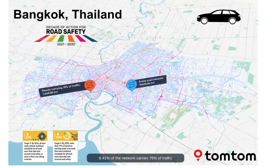
TomTom have prepared visualisations of the data at a country level (UK), state level (Michigan, USA) and city level (Bangkok, Thailand) to show what is possible. Abley have also prepared some initial 75% of travel maps for vehicles to help countries get started on their important journey to meet the 2030 Targets for 3-star or better roads for all.
For pedestrians and cyclists Dok data and road safety have been working with iRAP to develop maps that detail where 75% of travel is for bicyclists. Examples from Europe show that 75% of travel for cyclists occurs on an estimated 5.5% of the network in Rotterdam and an estimated 11.6% of the network in Barcelona. Read more here
Targeting iRAP assessments to these high-flow networks and investing in all the relevant treatments that maximise lives saved and serious injuries reduced is achievable. With infrastructure upgrades and speed management available to elevate journeys to the 3-star or better standard for all road users, every country can achieve the UN Target 4 and ensure that safer roads make their contribution to halving road deaths and injuries by 2030.
For more information
- To learn more about AiRAP click here
– ENDS –
Location: City level (Bangkok, Thailand)
Location: State level (Michigan, USA)
Location: Country level (UK)


Media enquiries:
For iRAP:
Judy Williams, Global Programme and Communications Manager
Email: judy.williams@irap.org
Mob: +61 400 782 204


