
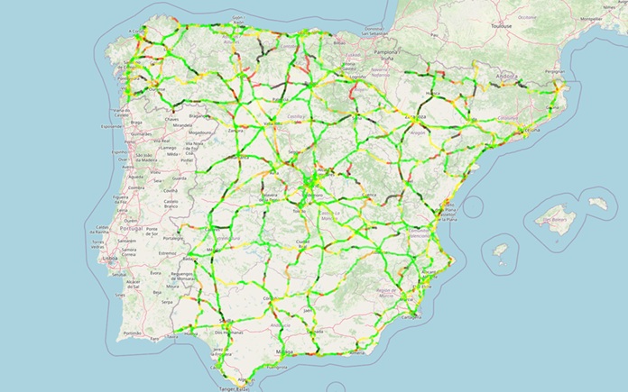
Each year, for over 20 years, the Reial Automobil Club de Catalunya (RACC) maps crash risk across Spain’s road networks based on the iRAP methodology, to inform evidence-based investment and advocacy. Three analyses released in the last six months for the 2022-2024 triennium have revealed that for the first time in 15 years, the risk index for the Ministry’s highways and expressways has increased, and the crash risk faced by motorists travelling roads in the Girona and Tarragona regions.
Annual Crash Risk Mapping of the State Road Network
RACC’s 22nd edition of annual Crash Risk Mapping for the government-owned State Road Network (RCE) shows that for the first time in 15 years, the risk index for the Ministry’s highways and expressways has increased.
The 26,470 km assessment of the RCE identified the stretches of interurban roads with the highest risk of a serious or fatal crashes occurring, assessed in relative terms according to the number of vehicles travelling on them.
Os resultados mostram:
- 11.8 per cent of the RCE’s total length poses a high or very high risk to drivers of being involved in a serious or fatal traffic crash.
- The top 10 sections with the highest risk on the RCE are divided single-carriageway roads with one lane in
each direction. The risk index on these roads is nearly four times higher than the risk index on high-capacity highways and motorways. - Compared to last year’s report, the risk index for divided roads in the RCE as a whole has remained at 24.4, while the risk index for high-capacity highways and expressways has risen from 6.1 to 6.4.
Overall, 3,595 sections of the RCE were analysed. The RCE accounts for 16 per cent of the length of Spanish roads, and carries 53 per cent of total traffic. A total of 3,873 crashes resulting in fatalities or serious injuries occurred on the RCE in the three-year period, of which 1,192 were fatal crashes resulting in 1,341 fatalities.
Para mais informações sobre o estudo e os resultados, clique aqui (em espanhol).
Annual Crash Risk Mapping for Girona
The RACC’s 24th edition of annual Crash Risk Mapping of the road network in the Girona region has highlighted that trucks are involved in 55 per cent of serious crashes on sections of the AP-7 motorway as it passes through Girona.
The iRAP study identified the sections of intercity roads with the highest risk of serious or fatal crashes, assessed in relative terms based on the volume of traffic. The analysis focused on the road network under the jurisdiction of the Spanish State, the Catalan Government (Generalitat de Catalunya), and the Girona Provincial Council (Diputació de Girona).
In total, 1,216.2 km of roads (intercity and through roads) were analyzed, representing 50 per cent of the total road network in Girona. These roads carry 91 per cent of all road traffic in the region and have been the site of 83 per cent of crashes resulting in fatalities and serious injuries.
Results showed:
- The risk of having a serious or fatal crash on a divided single carriage-way road is six times higher than on a dual carriageway.
- On sections of the AP-7 motorway, as it passes through the Girona region, trucks are involved in 55.3 per cent of serious crashes, despite only representing 27.3 per cent of total traffic.
- During the three-year period, at least one motorcycle or moped was involved in 40 per cent of all fatal traffic crashes. It should be noted that this type of vehicle represents only 2.1 per cent of total road traffic.
- 50 per cent of serious and fatal motorcycle crashes are concentrated in 20.5 per cent of the network length (249 km).
Para mais informações sobre o estudo e os resultados, clique aqui.
Annual Crash Risk Mapping for Tarragona
The RACC’s 22nd edition of annual Crash Risk Mapping of the road network in the Tarragona region has highlighted that the Baix Camp, Tarragonès and Baix Penedès regions account for 80 per cent of the road sections with the highest crash risk.
The iRAP study focused on the road network under the jurisdiction of the State, the Generalitat of Catalonia, and the Tarragona Provincial Council.
In total, 1,213.5 km of intercity and through roads were analyzed, representing 44 per cent of the total road network. These roads carry 86 per cent of all road traffic in the region and have accounted for 76 per cent of crashes resulting in fatalities and serious injuries.
Results showed:
- Serious and fatal crashes increased by 11.5 per cent, while overall road traffic increased by 5.6 per cent. As a result, the accident risk index increased by 4.9 per cent across the entire road network.
- The kilometres of “high” and “very high” risk represent 21 per cent of the network, 10 percentage points more than last year.
- On the Tarragona iRAP network, at least one motorcycle or moped was involved in 35 per cent of all traffic crashes resulting in deaths and serious injuries (21 per cent in the case of fatal crashes). Fifty per cent of serious and fatal motorcycle crashes occurred within 20.1 per cent of the network’s length (242 km).
Para mais informações sobre o estudo e os resultados, clique aqui.
Article and images credit: RACC